Annapurna Region
Annapurna Region Trekking in Nepal: The Complete Planning Guide
The Annapurna Region is Nepal's most visited trekking destination, and it earns that title without much argument. It sits north of Pokhara, Nepal's second-largest city, making logistics genuinely simple compared to getting to the Everest region. You land in Kathmandu, take a 25-minute flight or a roughly seven-hour bus ride to Pokhara, and you are already at the gateway. From there, the trails start within half-a-day’s drive.
But easy access does not mean the experience is diluted, absolutely not. The region is home to Annapurna I at 8,091 m, the 10th highest mountain on earth, along with Dhaulagiri, Machhapuchhre, Manaslu, and a handful of other giants. The terrain runs the full spectrum: subtropical forests below 2,000 m, dense rhododendron belts in the mid-hills, high alpine meadows, and eventually the stark, windswept terrain of the Mustang plateau. In a single multi-week trek, you pass through all of it.
The region also has a strong cultural layer. Gurung, Magar, Thakali, and Manangi communities live along the trails, each with distinct traditions, architecture, and food. You will walk through villages where people still practice terrace farming the same way their ancestors did, and then stop for dinner at a teahouse with a Wi-Fi password written on a chalkboard. That combination is part of what makes the Annapurna Region different from more remote destinations in Nepal.
This blog covers the main treks, best seasons, permits, logistics, and everything else worth knowing before you plan a trip.
Overview of the Annapurna Region
Geography and Landscape Diversity
The Annapurna Conservation Area (ACA) covers 7,629 sq km, making it the largest protected area in Nepal. Within that space, the altitude range is extraordinary: from river valleys below 1,000 m to the Thorong La Pass at 5,416 m, all within the same trekking circuit. That elevation spread produces wildly different ecosystems stacked on top of each other.
The lower sections below Pokhara and along the Marsyangdi River valley are warm, humid and green. Rice paddies and banana trees line the trail. Higher up, oak and rhododendron forests take over, and in spring the hillsides turn red and pink when the rhododendrons bloom, just as beautiful as seen in those viral Instagram reels.
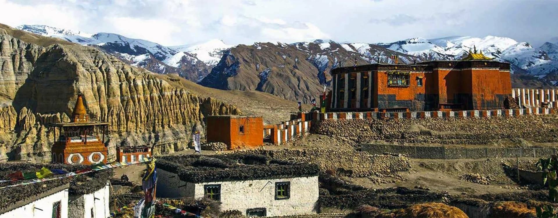
Above the treeline, the terrain shifts to rocky alpine meadows. Once you cross into the rain shadow of the Himalayan wall, the dry, high-altitude desert landscape of the Kali Gandaki valley overrides your senses. The gorge between Annapurna and Dhaulagiri is considered the world's deepest river gorge by some measures. It is worth pausing to take that in when you are standing at the bottom of it.
Cultural Significance and Local Communities
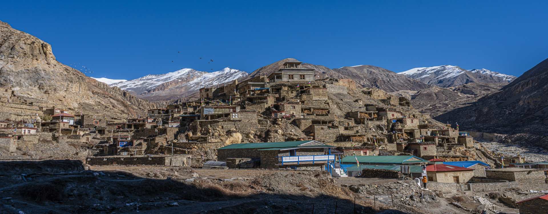
The ethnic mix in the Annapurna Region is part of what makes the trekking experience here genuinely interesting. In the lower hills around Ghandruk and Ghorepani, the trail passes through Gurung villages. The Gurung are known historically as soldiers, and their villages tend to be well-built and relatively prosperous. Further along the circuit, in the Kali Gandaki valley and around Marpha and Tukuche, the Thakali community has historically dominated trade between the Tibetan plateau and the lowlands. Thakali teahouses are famous for their food.
In the upper circuit around Manang and Pisang, the culture shifts toward a Tibetan Buddhist influence. Mani walls, prayer wheels, and chortens appear along the trail. Monasteries sit above villages on rocky outcrops. The language, the food, the architecture all change noticeably from what you encountered two days earlier at lower altitudes. That kind of transition is built into the route.
Accessibility and Connectivity
Pokhara is the main hub for Annapurna Region trekking. It has a domestic airport with several flights daily from Kathmandu. The drive from Kathmandu takes around seven hours on a good day. Most trekkers opt for the flight to save time, but the bus is a legitimate option if you have a day to spare and no strong objections to mountain roads.
From Pokhara, the specific trailhead depends on which route you are doing. Nayapul is the standard starting point for Poon Hill and Annapurna Base Camp treks. The Annapurna Circuit begins much further north, near Besisahar, which is accessible by road from Pokhara or Kathmandu. Teahouses are established along all the main routes, so you do not need to carry a tent or cooking gear for most standard itineraries.
Why Choose Annapurna Region Trekking in Nepal
Scenic Variety in a Single Journey
Most Himalayan trekking destinations give you one type of landscape done exceptionally well. The Annapurna Region gives you five or six. The transition from subtropical jungle to rhododendron forest to alpine meadow to high-altitude desert happens gradually, day by day. You wake up each morning to a different view. That progression is the circuit's greatest strength.
The mountain views are not concentrated in one spot, either. You see the Annapurna massif from multiple angles over multiple days. Dhaulagiri fills the horizon to the west in the Kali Gandaki section. Machhapuchhre, the iconic fishtail peak, dominates the view from the Annapurna Base Camp trail. Manaslu appears on the horizon early in the circuit. There is no single best viewpoint because the whole route functions as a continuous panorama.
Flexible Travel Experience
The Annapurna Region accommodates a wide range of trip lengths. The Poon Hill Trek takes four to five days and is suitable for people with limited time or limited trekking experience. It tops out at 3,210 m. The Annapurna Circuit, at the other end of the spectrum, takes 12 to 18 days and crosses a 5,416 m pass. Between those two extremes, there are a dozen viable routes of varying length and difficulty.
The Annapurna Base Camp trek is a popular middle-ground option: seven to twelve days, reaching 4,130 m, and finishing in a natural amphitheatre of Himalayan peaks. The Mardi Himal trek has become increasingly popular in recent years as a less crowded alternative in the same area. The point is that you can match the itinerary to your fitness level, available time, and appetite for altitude without leaving the region.
Strong Tourism Ecosystem
The teahouse infrastructure in the Annapurna Region is the best developed in Nepal. On popular routes like the ABC and Poon Hill, teahouses are spaced every few hours of walking. Most have private or semi-private rooms, decent meals, and phone charging facilities. On the Circuit, the situation varies: the lower sections have solid options, but above Manang the choices thin out and quality drops. That is normal for high altitude. Pack accordingly and adjust expectations.
Communication is generally good on the main routes. Phone signal from NTC and Ncell reaches most villages up to reasonable altitudes. Wi-Fi is available at most teahouses, usually for a small fee. Emergency evacuation infrastructure has improved significantly in recent years; helicopter rescue from most points on the main routes is realistic given advance insurance coverage.
Best Time and Climate Insights
Peak Seasons: Spring and Autumn
Autumn, from September through November, is the busiest and most popular season. The monsoon has cleared the dust and haze from the atmosphere, and the skies tend to be stable and clear. Mountain visibility is at its sharpest. Temperatures at mid-altitude are comfortable during the day and cold at night above 3,000 m. October is the peak month, and the main routes can feel genuinely crowded. If you want the same weather with fewer people, early September or late November are better choices.
Spring runs from March through May. It is the second-best season. The rhododendron forests below 3,500 m are spectacular in March and April, and daytime temperatures are warmer than in autumn. The downside is atmospheric haze. Dust and moisture in the air from lower elevations can soften distant mountain views in April and May. April is generally the sweet spot before the haze builds. Above 4,000 m, pre-monsoon storms become a risk in May, so later spring requires more careful daily planning.
Off-Season Opportunities
Winter, from December through February, is underused by most foreign trekkers. Trails at lower elevations, including the Poon Hill circuit and the lower sections of the ABC trail, are perfectly walkable and largely empty. You will often have teahouses almost to yourself. The cold is real above 3,000 m, and the Thorong La Pass on the Annapurna Circuit can be blocked by snow, making that crossing risky or impossible in January and February. But for shorter, lower-altitude options, winter is a legitimate season with clear skies and quiet trails.
The monsoon from June through August brings heavy rain, leeches on lower trails, and reduced mountain visibility most of the time. However, the Annapurna Region has a distinct advantage here: the Kali Gandaki valley and the upper sections around Manang sit in the rain shadow of the Himalayan wall and receive considerably less rain than the southern approaches. Trekkers willing to deal with some wet weather on the access sections can find surprisingly dry and dramatic conditions in the upper circuit during monsoon months.
Temperature and Weather Conditions
Temperature varies enormously based on elevation. In Pokhara at around 800 m, daytime temperatures in October sit around 25–28°C. At Manang at 3,540 m, the same time of year produces daytime highs of 10–15°C and nights that drop well below freezing. On the Thorong La Pass crossing, temperatures can be anywhere from -10°C to -20°C with wind chill in the early morning hours when most trekkers cross. Layering is not optional on the circuit; it is the whole strategy.
The Main Treks in the Annapurna Region
Annapurna Circuit Trek
The Annapurna Circuit is the flagship route and has been consistently rated among the world's best long-distance treks for decades. It circumnavigates the entire Annapurna massif, covering 160 to 230 km depending on the variant and how much of the road sections you choose to walk versus drive. The standard itinerary runs 12 to 18 days.
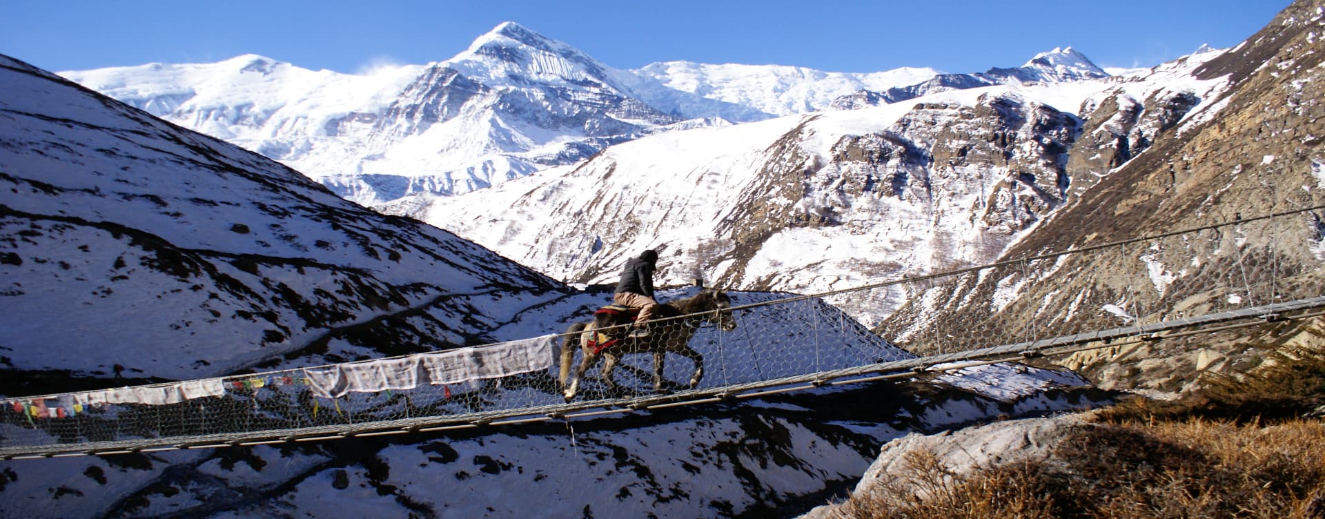
The circuit is hiked anticlockwise for good practical reasons. Starting from the Marsyangdi River valley and ascending gradually through villages like Chame, Pisang, and Manang allows your body to acclimatize progressively before the Thorong La crossing. Manang at 3,540 m is the designated acclimatization stop, where most itineraries include a full rest day. Side hikes to Gangapurna Lake and Ice Lake are standard options on that rest day and are worth doing.
Thorong La Pass at 5,416 m is the crux of the route. Most trekkers leave Thorong Phedi or High Camp well before dawn to reach the pass before winds pick up in the afternoon. The crossing takes four to six hours depending on fitness and conditions. The descent to Muktinath on the far side is steep and adds another two to three hours. Muktinath itself, a pilgrimage site sacred to both Hindus and Buddhists, is worth an afternoon to explore before continuing down into the Mustang valley.
One thing worth knowing: road construction has changed parts of the classic circuit. A road now runs through much of the Marsyangdi valley and the Kali Gandaki section. Guides familiar with the Natural Annapurna Trekking Trails (NATT) can route you onto marked foot trails that avoid the road. If walking along a dirt road with occasional jeeps is not what you signed up for, make sure your agency knows to use these alternative trails.
Annapurna Base Camp Trek
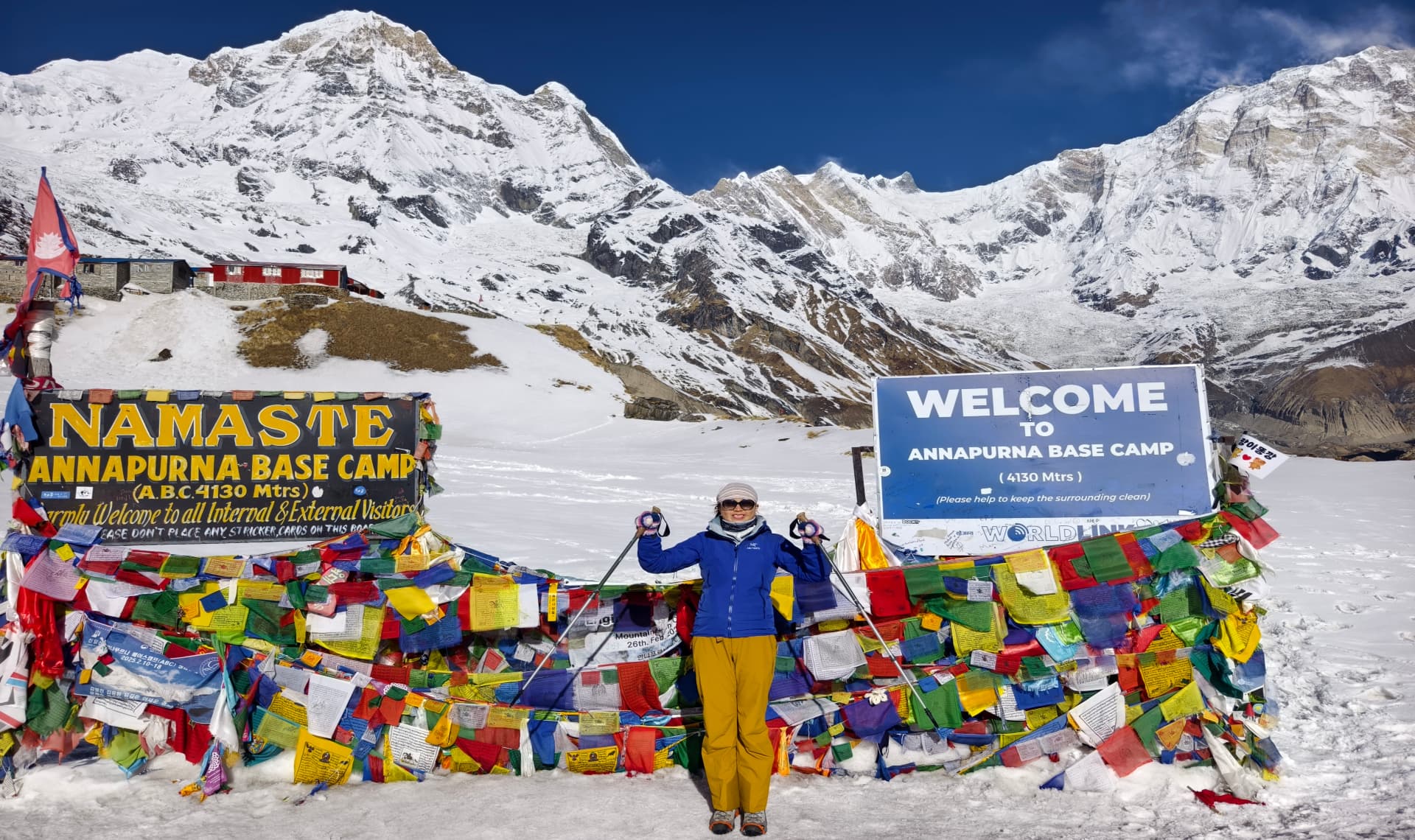
The Annapurna Base Camp trek, commonly called ABC, is a direct out-and-back route into the heart of the Annapurna Sanctuary. It tops out at 4,130 m and takes seven to twelve days from Pokhara depending on the route variation and your pace. It is rated moderate and is a strong choice for first-time high-altitude trekkers who want a genuine Himalayan experience without the commitment of the full circuit.
The final destination is a natural glacial basin ringed by ten Himalayan peaks above 6,000 m, including Annapurna I, Machhapuchhre, Hiunchuli, and Annapurna South. The enclosed nature of the base camp bowl creates a genuinely dramatic mountain environment that feels different from viewpoints elsewhere in the region. Sunrise in the sanctuary, when the first light hits the surrounding peaks, is one of the more memorable mornings available on any Nepal trek.
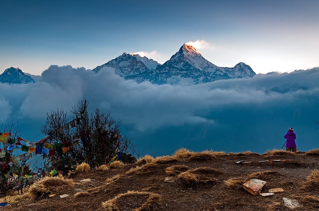
Ghorepani Poon Hill Trek
This is the standard introductory trek in the Annapurna Region, and the reputation is deserved. In four to five days, the route climbs through Gurung villages and rhododendron forests to Poon Hill at 3,210 m. The pre-dawn climb to the viewpoint there delivers a panoramic view of Dhaulagiri, Annapurna South, and Machhapuchhre that genuinely earns the early wake-up call. The trail is well-maintained and clearly marked. Altitude is not a serious concern. It is the right trek if your time is limited or if you are building toward a longer future trip.
Mardi Himal Trek
The Mardi Himal trek has grown steadily in popularity over the past several years as trekkers look for less-crowded alternatives near the ABC route. It takes five to seven days, reaches a high camp at around 4,500 m, and offers close views of Machhapuchhre and Mardi Himal without the high traffic of the main ABC trail. The teahouse infrastructure is less developed than on the primary routes, which is part of the appeal if you prefer quieter conditions.
Planning Annapurna Region Trekking in Nepal
Permits and Regulations in 2026
The permit situation for the Annapurna Region is relatively straightforward compared to some other areas of Nepal. Here is what applies as of 2026.
The Annapurna Conservation Area Permit (ACAP) is the primary mandatory permit for all trekking routes within the conservation area. This includes the circuit, ABC, Poon Hill, Mardi Himal, and all other standard routes. The cost is NPR 3,000 for foreign nationals, payable in Nepalese rupees. The permit can be obtained at the Nepal Tourism Board office in Kathmandu or Pokhara, or through a registered trekking agency. It can also be processed online with an additional 2.9% payment gateway charge. Children under 10 do not require the permit.
TIMS card status for the Annapurna Region has evolved. As of April 2023, the TIMS card is no longer required for the Annapurna region. The ACAP now functions as the primary registration document. However, rules are updated periodically. Always verify the current requirements with your agency or the Nepal Tourism Board before you travel.
For trekking in restricted areas within or adjacent to the Annapurna Region, such as Nar Phu Valley, a Restricted Area Permit (RAP) is additionally required and must be arranged through a registered trekking agency. Since March 2026, solo trekkers can now obtain restricted area permits without needing a second companion, following a regulation update by TAAN. A licensed guide through a registered agency is still mandatory.
The Mandatory Guide Requirement
Since April 2023, all foreign trekkers in Nepal's conservation areas and national parks are required to trek with a licensed guide employed through a government-registered trekking agency. This applies to the Annapurna Region. Independent solo trekking without a guide is not permitted on any of the main routes. The rule is enforced at permit checkpoints, and attempting to trek without a guide can result in fines or removal from the trail.
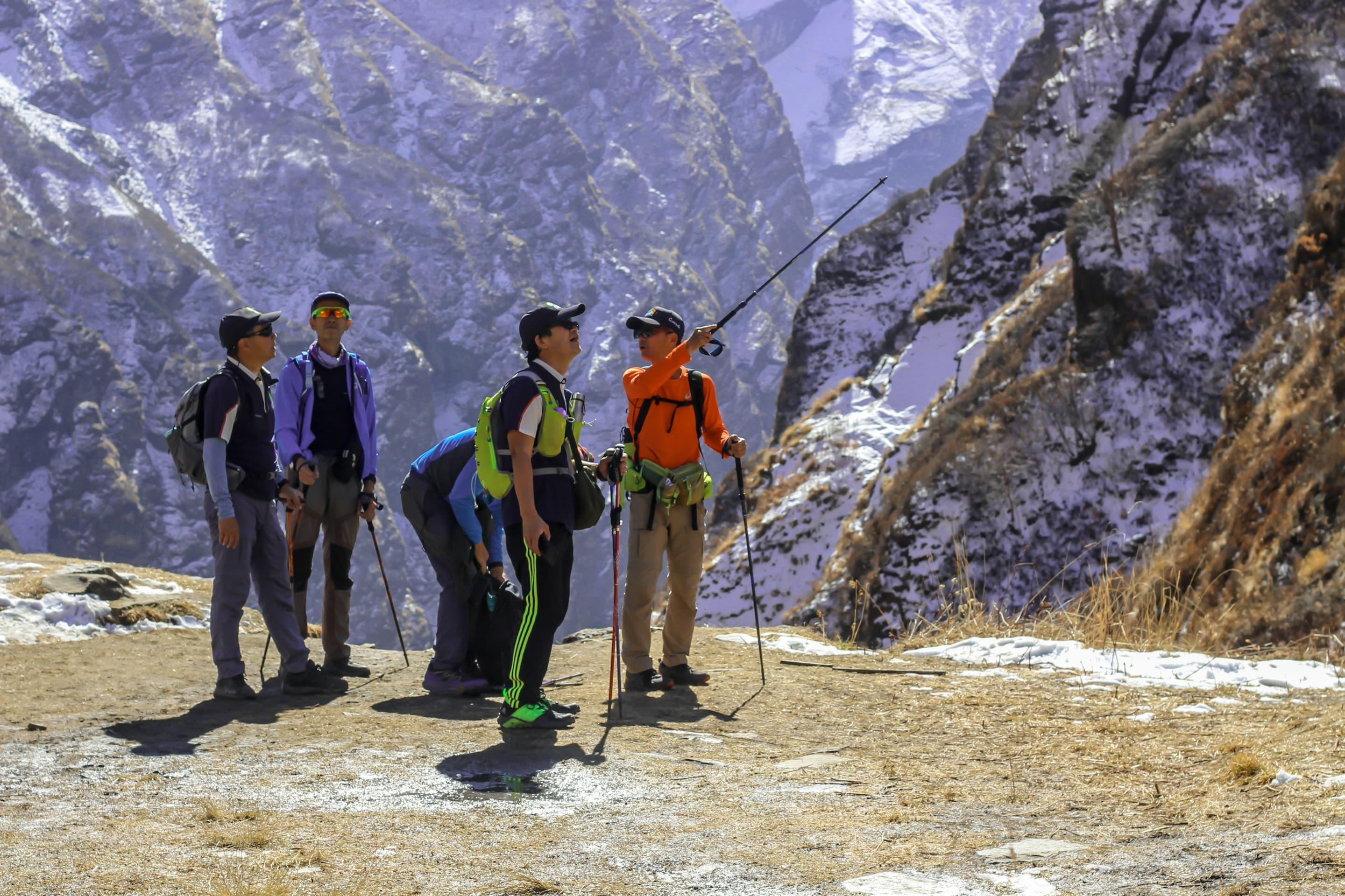
For most trekkers, this is not a problem in practice. A good guide adds real value: they handle logistics, provide cultural context, and are trained to recognize early signs of altitude sickness. The regulation formalizes what experienced trekkers have always recommended anyway. Hire through a TAAN-registered agency, verify the guide's license, and clarify the itinerary and porter arrangements before you leave Pokhara.
Logistics and Preparation
Most organized treks include airport pickup, accommodation in Pokhara before and after the trek, and all ground transport to and from trailheads. What varies is what happens in between: meal costs on the trail are typically not included in package prices and are paid at each teahouse. Budgeting NPR 2,000 to 3,500 per day for food on the trail is reasonable depending on the altitude and how remote the section is.
Physical preparation matters. The Poon Hill trek requires modest fitness. The Annapurna Circuit is a different proposition; you will be walking five to seven hours per day on uneven terrain at altitude for nearly two weeks. Three months of regular cardio and leg strength training before departure is a sensible minimum. Carrying a loaded daypack on training hikes at home helps more than any gym-only routine.
Safety and Altitude Acclimatization
Altitude sickness is the main safety concern on any Annapurna Region trek above 3,000 m. The standard rule applies: ascend slowly, follow the principle of climbing high and sleeping low, and include rest days as built into your itinerary rather than trying to skip them. Manang is the designated acclimatization stop on the circuit for good reason. Skipping the rest day there to save time is a consistent source of problems at Thorong La.
Know the symptoms of Acute Mountain Sickness: persistent headache, nausea, dizziness, and difficulty sleeping. These symptoms at altitude are a signal to stop ascending. If they worsen, descend. Descending even 300 to 500 m brings rapid relief in most cases. Your guide should be trained in AMS recognition; confirm this when booking. Carry basic personal medication as advised by a travel medicine doctor before departure.
Travel insurance with coverage for high-altitude trekking and helicopter evacuation is not optional. Helicopter rescue from the Annapurna Region is logistically possible on most routes, but it costs money that the Nepali government and local communities should not be expected to cover. Make sure your policy explicitly covers the altitudes you plan to reach and includes emergency medical evacuation.
Conclusion
The Annapurna Region delivers what most trekkers are actually looking for: genuine Himalayan mountain scenery, cultural variety, manageable logistics, and a route that can be calibrated to different fitness levels and available time. It is not a secret, and the popular routes do show their traffic in peak season. But the quality of the experience holds up even when the trail is busy, because the landscape is simply that varied and that large.
If you have a week, the Poon Hill or Mardi Himal trek delivers the highlights without overextending a schedule. If you have two weeks and reasonable fitness, the Annapurna Circuit is one of the most complete trekking experiences available anywhere in the Himalayas. The Annapurna Base Camp sits between those two options and is an excellent starting point for first-time high-altitude trekkers.
Book through a TAAN-registered agency, sort your ACAP permit in advance, make sure your guide is licensed, and plan your acclimatization days properly. After that, the region tends to take care of the rest.
Frequently Asked Questions
Where is the Annapurna Region located?
The Annapurna Region sits in central Nepal, directly north of Pokhara. It is contained within the Annapurna Conservation Area, which covers 7,629 sq km of terrain ranging from subtropical river valleys to high Himalayan passes. Pokhara is the primary access hub, reachable by a 25-minute domestic flight or a roughly seven-hour drive from Kathmandu.
What permits are required for Annapurna Region trekking in 2026?
The Annapurna Conservation Area Permit (ACAP) is the primary mandatory permit, costing NPR 3,000 for foreign nationals. As of 2023, the TIMS card is no longer required for the Annapurna region. Trekking in restricted sub-areas like Nar Phu Valley requires an additional Restricted Area Permit (RAP), which must be arranged through a registered trekking agency. Always verify current requirements before travel, as regulations are updated periodically.
When is the best time for Annapurna Region trekking in Nepal?
Autumn (September to November) and spring (March to May) are the two main seasons. Autumn offers the best mountain visibility with stable, clear weather. Spring brings warmer temperatures and rhododendron blooms but some atmospheric haze in April and May. Winter (December to February) works well for lower-altitude routes like Poon Hill. The monsoon (June to August) is generally not recommended for the main routes, though the rain-shadow sections of the upper circuit remain relatively dry.
Is the Annapurna Region suitable for beginners?
Yes, for the right routes. Poon Hill and the lower sections of the Mardi Himal trek are accessible to people with basic fitness and no previous trekking experience. The Annapurna Circuit and ABC treks require more preparation and a reasonable fitness base. Altitude is the main variable; routes that stay below 3,500 m are manageable for most people. Routes that go higher require proper acclimatization planning and an honest assessment of your physical condition beforehand.
Do I need a guide for Annapurna Region trekking?
Yes. Since April 2023, all foreign trekkers in Nepal's conservation areas are legally required to be accompanied by a licensed guide hired through a government-registered trekking agency. This applies across the Annapurna Region. Trekking without a guide on the main routes can result in fines or being turned back at checkpoints.
How difficult is the Thorong La Pass crossing on the Annapurna Circuit?
It is the hardest day on the circuit but manageable for anyone who has acclimatized properly. The crossing from High Camp to the pass summit takes three to four hours of steady uphill walking at altitude. Most trekkers start at 3:00 to 5:00 AM to beat afternoon winds. The descent to Muktinath on the far side takes another two to three hours. Proper rest at Manang beforehand, no rushing the ascent schedule, and an early start on crossing day are the three factors that determine success most reliably.