No cancellation fees. No hassle. Book Now, stay relaxed.Cancellation Terms
Accessible Adventure
Outbound
Trekking in Nepal
Expeditions
Activities
Travel Guide
Company
Home/trekking in nepal/Dolpa region Trekking

Dolpa region Trekking

Dolpa region Trekking

Dolpa, also called Dolpo in the local tongue is the largest district in Nepal located in the northern far-west. Even though Dolpo covers an area of about 7889 square kilometers, it has one of the lowest number of people inhabiting it. As such, much of Dolpo is left untouched by human civilization. Here you can find nature in its purest form. Being largely located towards the north of the Himalayan mountain range, Dolpo receives little to no rainfall, making the region barren. What Dolpo lacks in vegetation, it makes up for in its majestic hills and views of the mountains which are sure to keep you mesmerized.

Due to the barren landscape, the lifestyle of Dolpo is still very primitive, relying mostly on Yaks and mules for transportation and dry timber as fuel for cooking. The region seems almost left behind by modernization, and the many hassles and stresses of modern life. The people there still wear traditional attire and speak a language known to very few.

One of the oldest human settlements was in the region of Dolpo and many ruins of ancient civilizations can still be found here. The area also includes the famous Dho Tarap, one of the very rare high altitude human settlements in the world. Settlements like Tinje, Chharka, Kagkot and Mukat will have your imagination running wild, trying to figure out what the place looked like many centuries ago.

Yarsa-Gumba is a special type of fungi that is found in the region of upper Dolpa. When a caterpillar gets infected by a special type of fungus, it basically becomes mummified and this fungus is called Yarsagumba. Yarsagumba is used in the many traditional medicines of Nepal and Tibet and is highly sought after as an aphrodisiac and for its medicinal properties. One piece of Yarsagumba can go for as high as RS2000, making it extremely valuable and expensive. Every summer, the region of the Phoksundo National Park opens itself up to locals who travel in the dozen to hunt for yarsagumba. Many unfortunately do not make it back due to the harsh conditions in the region of upper dolpo.

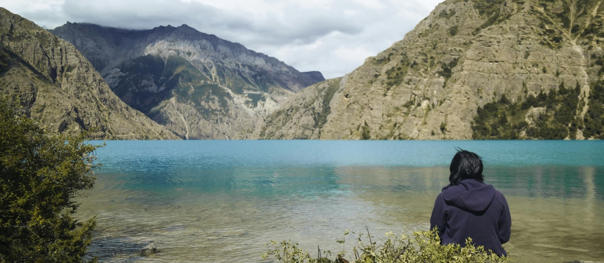
The pristine Shey Phoksundo lake lies in the Dolpo region. The bright blue hue of the lake surrounded by dry mountains surely makes Phoksundo the most beautiful lake in Nepal. Virtually untouched by humans, the water there is clean, clear and blue. The lake itself is the deepest lake in Nepal and is located at an altitude of 3611m. The lake has been designated as a RAMSAR site, an important water resource.

The ancient Tibetan religion of Bon  is retained in Dolpo, with many esoteric and secret practices and deities unlike those in Buddhism and Hinduism. The ancient tradition of Sky-burial, where dead bodies are cut up and fed to the eagles and vultures as a way to dispose of the bidy is retained in Dolpo region as well.

Thus any enthusiast of history, rare and esoteric cultures and wonderful cold-desert views will find Dolpo to be heaven and is definitely a must visit in Nepal.

Available Packages

2 carefully curated packages to match your adventure style

Upper Dolpo Trekking
10% OFF
24 Days
5,360 m / 17,585 ftm

Upper Dolpo Trekking

A Trek That Very Few Trekkers Ever Attempt

Fewer than a few hundred international trekkers reach Upper Dolpo in any given year. The numbers have not grown substantially since the region was first opened to foreign visitors in 1988. That low footfall is not an accident. The Upper Dolpo Circuit requires more time, more money, and more physical capacity than any other standard trekking package in Nepal. The permit alone costs USD 500 per person for the first ten days, a deliberate policy set by the Nepalese government to limit tourist density in a region considered too fragile and too culturally significant for mass tourism.

Those filters do their job. What you find when you arrive is a landscape and a culture that have largely run on their own terms for centuries. No road connects the interior villages to the outside world. The high passes close with snow for much of the year. The people who live here, often called Dolpo-pa, have adapted over generations to one of the most demanding living environments on the planet, building their stone houses into cliff faces, farming at altitudes that would stop most crops, and maintaining religious traditions that trace back to before Buddhism reached the Himalayas.

The Upper Dolpo Circuit covers approximately 244 to 247 kilometers on foot over the central trekking days. It crosses three major passes: Kang La at 5,360 meters, Saldang La at 5,200 meters, and Jeng La at 5,090 meters. It passes Phoksundo Lake, the deepest alpine lake in Nepal, and it ends at Shey Gompa, the spiritual heart of the entire Dolpo region, before looping back through the remote northern villages and returning via the long descent to Juphal. It is a full journey through one of the least-visited corners of Asia.


What Makes the Upper Dolpo Circuit Different

Most Nepal treks ask you to choose between mountain scenery and cultural depth. The Upper Dolpo circuit offers both without compromise. The landscapes here shift every few days in ways that keep the experience visually fresh for three weeks. You walk through dense pine gorges below 3,000 meters, then cross into open plateau country that feels closer to the Tibetan tableland than to anything in the rest of Nepal. The rain shadow created by the Dhaulagiri massif means the inner valleys receive very little monsoon precipitation, giving them a stark, dry character unlike anything on the southern side of the Himalayan range.

The cultural layer is equally distinct. The dominant religion in the interior villages is not Tibetan Buddhism but Bon, the older spiritual tradition from which some Buddhist practices eventually derived. In Saldang, the largest village in Upper Dolpo, and in the settlements around Shey Gompa, you are walking through living Bon communities. The monasteries here are active, the monks are young as well as old, and the festivals are observed by the full village rather than for tourist visitors. The distinction is real and noticeable if you spend time in the places rather than just passing through.


Highlights of the Upper Dolpo Circuit Trek Package

  • Kang La Pass (5,360 m): The highest point of the circuit and one of the highest trekking passes in Nepal. The crossing requires an early start and sustained climbing, but the views from the summit span the entire western Himalayan arc.

  • Shey Gompa and Crystal Mountain: An 800-year-old monastery at the base of a peak whose cliffs are coated in quartz crystal and embedded with marine fossils. This is the destination that Peter Matthiessen described in his 1979 book 'The Snow Leopard,' widely regarded as one of the finest nature travel books in English.

  • Phoksundo Lake (3,611 m): Nepal's deepest lake, with water so blue-green it reads as color-saturated even on overcast days. The lake sits within Shey Phoksundo National Park and is sacred to the Bon tradition.

  • Saldang La Pass (5,200 m): The second major crossing of the circuit, reached from the spiritual enclave of Shey Gompa, connecting the inner Dolpo plateau to the northern network of villages that lie beyond.

  • Jeng La Pass (5,090 m): The third and final high pass on the circuit, dropping from the northern plateau back into the Tarap Valley and the culturally rich settlement of Dho Tarap.

  • Saldang Village: The largest and most substantial settlement in Upper Dolpo, sitting on a wide plateau at around 3,900 meters with views of Shey Shikhar and Kang Chunne. The village maintains active Bon and Chaiba Buddhist religious practices in parallel.

  • Yangze Gompa: A Bon monastery north of Saldang reached by following the Nagon Khola through barren terrain. The gompa houses centuries-old art and ritual objects rarely encountered outside this region.

  • Namdo and Sibu Villages: Prosperous villages south of Saldang with terraced fields, mani walls, and chortens that reflect the dense spiritual architecture of northern Dolpo.

  • Dho Tarap Valley (4,080 m): One of the world's highest inhabited settlements, a wide flat-bottomed valley with a tight cluster of stone buildings, multiple Bon monasteries, and a community that preserves ancient textile and agricultural traditions.

  • Full Camping Trek: Unlike routes with teahouse networks, the Upper Dolpo circuit is primarily a camping expedition. The team carries all tents, kitchen equipment, and food for the inner sections, giving you genuine wilderness immersion.


Detailed Journey Breakdown

Kathmandu and the Gateway Flights

The journey begins in Kathmandu with two days devoted to permits, gear checks, and the domestic flight down to Nepalgunj. The double-permit system for Upper Dolpo requires both a Lower Dolpo Restricted Area permit and a separate Upper Dolpo Restricted Area permit. Processing these through the Department of Immigration takes a full morning. The afternoon is typically used for sightseeing or last equipment purchases.

The Approach: Juphal to Phoksundo Lake

From Juphal at 2,320 meters, the first four days follow the Suli Gad River corridor upstream through a sequence of gorge sections, riverside villages, and forested hillsides. The elevation gain is gradual and well-structured, giving the body time to begin its altitude adjustment before reaching the lake. By Day 6 you arrive at Ringmo village and the edge of Phoksundo Lake, a stop that earns a full rest and exploration day. The turquoise water, the gompa on the lakeshore, and the proximity of Shey Phoksundo waterfall make this one of the better rest days in Himalayan trekking.

The Inner Dolpo Core: Kang La and Shey Gompa

Above Phoksundo Lake, the trail enters proper inner Dolpo. The approach to Kang La Pass follows the Phoksundo Khola northward into a high glacial valley where the landscape changes from pine to rock within a few kilometers. The base camp at Phoksundo Bhanjyang sits at around 4,400 meters and gives the body a partial adjustment night before the summit push. The crossing of Kang La at 5,360 meters is the physical and spiritual center of the entire circuit. Shey Gompa is less than a day below on the far side, and the rest day there allows a thorough visit to the monastery, Crystal Mountain, and the surrounding Bon settlement of Shey village.

Northern Villages: Saldang La, Namgung, and Saldang

From Shey, the route crosses Saldang La Pass at 5,200 meters and drops into the northern network of villages that make up the inner plateau population. Namgung, built into a cliff face in red stone, is one of the more memorable overnight stops. Saldang, the largest village in the upper region, sits on an exposed plateau with views north toward Tibet. From Saldang, a full day north along the Nagon Khola reaches Yangze Gompa, where the Bon monastery contains some of the most intact pre-Buddhist ceremonial art in Nepal. The return south through Namdo and Sibu brings you to the base of the final pass.

Jeng La and the Return Through Dho Tarap

The Jeng La crossing at 5,090 meters drops you into the Tarap Valley and the village of Tokyu, which marks the eastern edge of the Upper Dolpo circuit. From here, an easy walk through wetland and meadow brings you to Dho Tarap, where a rest day allows you to explore the Bon monasteries and recover before the long descent back to Juphal. The final trek days retrace the Bheri River corridor, giving you the route in reverse with different light and slightly different energy after 20-plus days in the mountains.

The Return Flight

The circuit closes at Juphal with the short flight back to Nepalgunj and the onward connection to Kathmandu. Three weeks in the mountains tends to make Kathmandu feel overwhelming for the first 24 hours, but the layover day is useful for rest, recovery, and reflection before the international departure.

Trip StyleFull Camping Trek
Difficulty
Easy to Moderate
Starting from
$5500$4948/ person
Lower Dolpo Circuit Trek
14% OFF
18 Days
5,190 m / 17,028 ftm

Lower Dolpo Circuit Trek

Step Into Nepal's Most Untouched Corner

The Lower Dolpo Circuit Trek is the kind of journey that most people talk about but very few actually take. Tucked into the far northwest of Nepal, the Dolpo region sits in a high-altitude rain shadow that gets less annual rainfall than some deserts. The land here is brown, wind-carved, and immense. Above the treeline, prayer flags mark passes that connect isolated valleys to one another. Down in the gorges, rivers run cold and clear over flat stones. This is a place where modernity genuinely has not arrived.

A 19-day window of walking and flying gets you into the core of what makes Dolpo so unusual. You start from Nepalgunj, which sits near the Indian border at less than 200 meters above sea level. Two days later, you are crossing stone bridges above glacial tributaries and watching porters carry loads on trails cut into cliff faces. The contrast is difficult to explain but easy to feel.

Beyond the scenery, this trek goes through one of the world's last places where Bon religion is still practiced in its original community context. Bon predates Buddhism and differs from it in specific rituals, temple layouts, and the direction of kora walks around sacred structures. In Dho Tarap village and the monasteries nearby, you can observe and quietly learn about this tradition from people who have carried it for generations.


What Sets This Trek Apart

Most Nepal treks take you along known corridors, busy in peak season, with teahouse comforts and cell signal at most stops. The Lower Dolpo Circuit is not that kind of trek. The trail crosses two serious high passes: Numa La at 5,190 meters and Baga La at 5,070 meters. Between those passes, you drop into wide valleys and camp in meadows used by yak herders. The route then finishes at Phoksundo Lake, a still, turquoise body of water held against steep limestone cliffs that gave this region a moment of international attention after the 1999 film "Caravan" was nominated for the Academy Awards.

The logistics are deliberately limited. There are no roads in the core trekking area. Some stretches have no teahouses at all. The team carries camping equipment to the high sections, and the sleeping arrangements get simple. That simplicity is the point. You hear your own footsteps. You notice the altitude. You start to understand the terrain on its own terms rather than from behind a glass window.


Highlights of the Lower Dolpo Circuit Trek Package

  • Phoksundo Lake: Nepal's deepest lake, perched at 3,611 meters with water so clear it reads turquoise-blue against the surrounding brown cliffs and pine forest edges.

  • Numa La Pass (5,190 m): The highest crossing on this route, with sweeping views across Dhaulagiri, Churen Himal, Shey Shikhar, and the Kanjiroba range on a clear morning.

  • Baga La Pass (5,070 m): The second major pass, reached through a valley of scattered seasonal yak shelters, with sacred chortens at the top marking the descent toward Phoksundo.

  • Dho Tarap Village: A wide, flat-bottomed valley settlement at 4,080 meters, home to a culturally distinct Bon community and a cluster of monasteries including Ribo Bompa and Mekyem Gompa.

  • Shey Phoksundo National Park: Nepal's largest national park by area, with rare wildlife including snow leopards, blue sheep, grey wolves, Himalayan tahr, and the vibrantly plumed Himalayan Monal.

  • Ancient Monasteries: Pre-Buddhist Bon gompas alongside Tibetan-style Buddhist temples, decorated with thangkas, Maitreya statues, and collections of ceremonial weapons.

  • Rain Shadow Landscapes: Dry, ochre-colored plateaus that shift into pine-filled gorges below 3,000 meters, giving the trek a visual range not found on wetter Himalayan circuits.

  • Remote Culture: Villages like Ringmo and Tarakot where residents wear traditional garments, practice subsistence farming, and host pack animals rather than tourist infrastructure.


Detailed Journey Breakdown

Arriving in Kathmandu and Nepalgunj

The trek starts in Kathmandu, where you sort permits, meet the team, and check gear. A short flight drops you to Nepalgunj, Nepal's largest mid-western city, sitting at 154 meters. The warmth and flat horizon feel almost surreal after months of imagining high mountains. Another small aircraft carries you up to Juphal the following morning, landing on a sloped grass-and-gravel strip at 2,320 meters that many pilots consider one of Nepal's more demanding domestic approaches.

The Approach through the Bheri River Corridor

Early trek days follow the Thulo Bheri River through a mix of cultivated terraces, pine-covered slopes, and gorge sections where the trail narrows against cliff walls. Villages like Dunai, Tarakot, and Laini each have their own character. Dunai is the district headquarters, relatively functional, with small shops and a checkpoint. Tarakot sits at an old trade crossroads and carries a layered history. As you climb toward Nawarpani and Dho Tarap, the valley opens and the landscape gradually empties of agriculture.

Dho Tarap and Cultural Immersion

The wide valley of Dho Tarap is one of the more memorable campsites on this entire circuit. The village is organized around a central lane flanked by stone houses, dried-meat racks, and monastery walls. Children and dogs move through the lanes with equal confidence. An acclimatization day here gives you time to visit the gompas properly, watch community life, and give your body a needed rest before the high passes ahead.

Crossing the High Passes

The ascent to Numa La starts from a base camp at around 4,440 meters. The trail goes across loose scree, through snow-filled gullies in early season, and up a final rocky headwall to the pass cairn. From the top, the view extends across an enormous field of mountains with no visible road, no structure, nothing except ridgelines and sky. The descent takes you through a U-shaped valley to an overnight at Pelung Tang. The following day brings Baga La, which demands similar effort but ends with the lake beginning to appear through the valley floor below.

Phoksundo Lake and the Return

Ringmo village is the last settlement before Phoksundo Lake. From the village, a short uphill walk reaches the lake edge, where the water color genuinely stops you. The depth of the blue-green hue comes from the lake's 145-meter depth and the glacial minerals that filter in from above. A rest day here allows for a thorough exploration of the shoreline, the lake-edge monastery, and the waterfall fed by the outflow. The return to Juphal via Chhepka closes the circuit, retracing sections of the Bheri River valley before the flight back.

Returning to Kathmandu

The reverse flight from Juphal through Nepalgunj to Kathmandu is brief but striking. Looking down from the plane at the terrain you spent two weeks walking through is a good moment for reflection. Back in Kathmandu, the rest day exists for that purpose: going over the experience at your own pace before the international departure.
 

Trip StyleTrekking | Cultural Immersion |Remote Himalayan Adventure
Difficulty
Easy to Moderate
Starting from
$3498$2995/ person
Accessible Adventure Logo
About Us

As Accessible Adventure, we are a trusted adventure tour operator, crafting unforgettable journeys across Nepal, Tibet, and Bhutan that leave lasting memories for every traveler.

Explore More
  • Blog
  • Travel Guide
  • Our Commitments
  • Online Payment
Company
  • Our Team
  • Terms and Conditions
  • No-risk Booking Policy
  • Legal Documents
Have Questions?
  • Phalful Chwok, Nayabazar-16, Kathmandu, Bagmati, 44600, Nepal
  • +9779851352707
  • info@accessibleadventure.com
Contact Us
đŸ‘„ Follow us:
FacebookX (Twitter)LinkedInInstagramYouTubePinterestTikTokWhatsAppViber

All content and photographs on this website are copyright © Accessible Adventure Pvt. Ltd. and may not be reproduced without prior written permission.

Developed byTuring Research And Development Private Limited ↗