Why Choose Everest Base Camp and Gokyo Lakes Trek?
Last updated
Two of the World's Greatest Himalayan Journeys, Linked by One High Pass
The two most celebrated trekking destinations in the Khumbu sit in adjacent valleys separated by a single glaciated pass. Everest Base Camp draws trekkers from every country on earth with the pull of the highest mountain and the legacy of the expeditions that have attempted it since 1953. The Gokyo Lakes offer something different: six sacred turquoise lakes on the moraine of Nepal's longest glacier, a summit viewpoint that many experienced Himalayan travelers rate above Kala Patthar for its 360-degree panorama, and a valley that carries a fraction of the traffic of the main base camp corridor. This 18-day itinerary visits both.
The route follows the standard Everest Base Camp trail from Lukla through Namche Bazaar, Tengboche, Dingboche, and Lobuche to the base camp itself at 5,364 meters. It then crosses Cho La Pass at 5,420 meters, a glaciated col that connects the Khumbu and Gokyo valleys, before descending to the Gokyo lake system and climbing Gokyo Ri at 5,357 meters. The return to Lukla follows the quieter Gokyo Valley trail. This is not a simple extension of the standard EBC route. It is a complete circuit through both valleys, with a high pass linking them and two separate summit viewpoints, each providing a different and complementary perspective on the greatest mountain range on earth.
The highest point of the trek is Kala Patthar at 5,545 meters, reached on Day 11 before the Cho La crossing. From Kala Patthar, the entire southern face of Everest is visible: the Khumbu Icefall below the southwest face, the South Col route, and the summit pyramid rising above Nuptse's wall. This is the view that most trekkers come to the Khumbu to see, and on a clear October or April morning it earns everything that has been said about it.
What Makes the EBC and Gokyo Lakes Trek Route Exceptional: Cho La Pass and Two Summit Viewpoints
The Cho La Pass crossing is the feature that elevates this trek above a simple base camp excursion with a Gokyo add-on. At 5,420 meters, the pass involves a glacier crossing with basic equipment (crampons are required and provided) and a steep rocky descent on the Gokyo side that demands careful footing. It is not a technical mountaineering objective, but it is enough to filter out the purely casual trekker and give the circuit a genuine sense of achievement beyond the destination visits.
The combination of viewpoints is the other defining quality. Kala Patthar at 5,545 meters gives the closest and most direct Everest view available on a trekking route. Gokyo Ri at 5,357 meters gives the widest panorama: Cho Oyu, Everest, Lhotse, Makalu, and the full sweep of the Ngozumpa Glacier in a single frame. Having both within the same itinerary, approached from opposite sides of the Cho La, gives a comprehensive picture of the western Khumbu that no single-valley route can match.
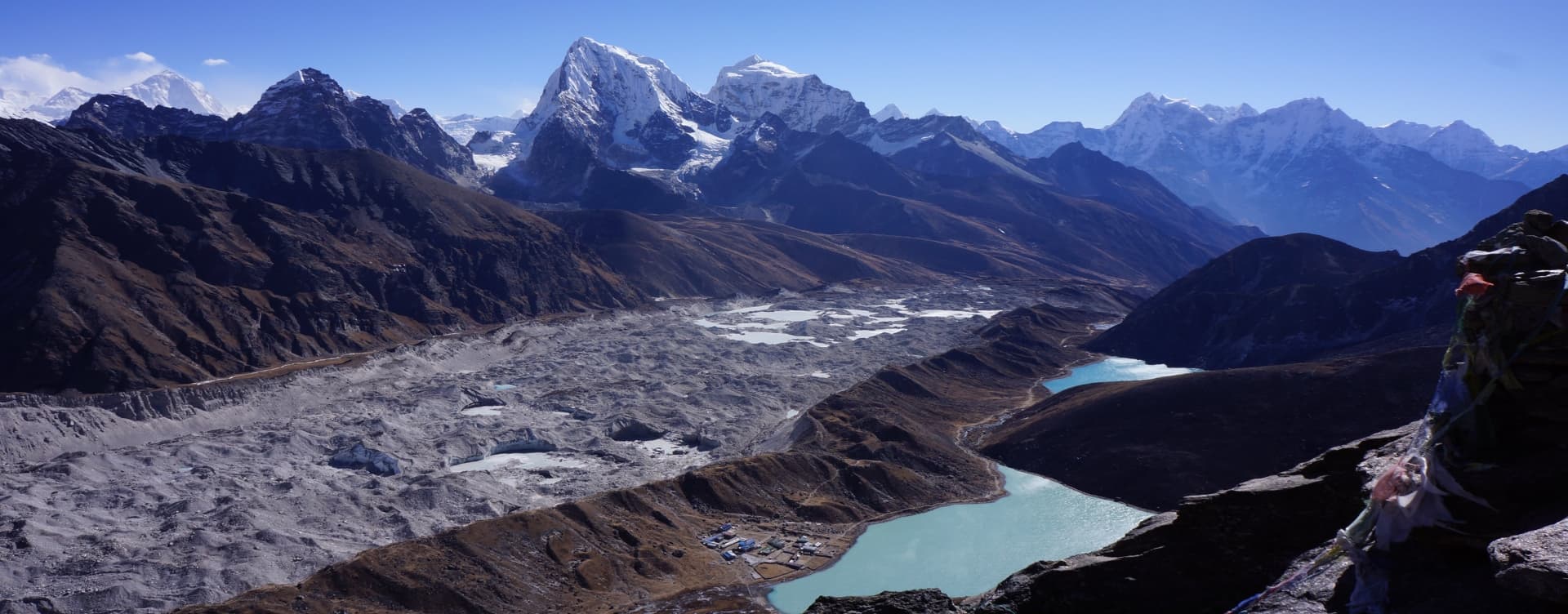
The Gokyo Lakes system is the cultural and natural heart of the western Khumbu valley. The six lakes are sacred in both Hindu and Buddhist traditions, fed by glacial meltwater and displaying the turquoise-blue color that comes from glacial minerals suspended in deep, cold water. The Ngozumpa Glacier, running the full western length of the valley at 36 kilometers, is Nepal's longest and visible in genuine scale from the lakeshore. The village of Gokyo, sitting on the flat shelf above the third lake, is one of the more peaceful overnight stops in the entire Khumbu region.
Highlights of the Everest Base Camp and Gokyo Lakes Trek
-
Everest Base Camp (5,364 m): The most famous trekking destination in the world, set at the foot of the Khumbu Icefall with the route of the South Col Everest expeditions visible above and the glacier debris of 70 years of climbing history beneath your feet.
-
Kala Patthar (5,545 m): The highest point of the trek and the finest single viewpoint of Everest's southern face available on any trekking route, reached at dawn on Day 11 for the sunrise view across the Khumbu.
-
Cho La Pass (5,420 m): A glaciated high pass connecting the Khumbu and Gokyo valleys, the technical centerpiece of the circuit, requiring crampons on the Khumbu side and careful route-finding on the rocky Gokyo descent.
-
Gokyo Ri (5,357 m): A 360-degree summit panorama covering Cho Oyu, Everest, Lhotse, Makalu, and the Ngozumpa Glacier that many experienced trekkers consider superior to the Kala Patthar view for its comprehensive width.
-
Six Sacred Gokyo Lakes: A chain of six glacially fed turquoise lakes on the Ngozumpa moraine, sacred to Hindu and Buddhist traditions, with the third lake Dudh Pokhari at 4,700 m as the visual centerpiece.
-
Ngozumpa Glacier: Nepal's largest glacier at 36 kilometers, running the full western length of the Gokyo Valley and visible from the lakeshore, moraine walks, Gokyo Ri, and the Cho La in dramatic scale.
-
Tengboche Monastery (3,860 m): One of the most revered Buddhist monasteries in the Himalayan region, set on a forested ridge with Ama Dablam directly behind it and Everest visible to the north.
-
Namche Bazaar (3,440 m): The commercial and cultural capital of the Khumbu Sherpa community, with a Saturday market, the Sherpa Museum, a wide range of teahouse accommodation, and the first clear Everest sightline above the ridge.
-
Khumbu Icefall Views: From Everest Base Camp, the Khumbu Icefall rises directly above: a chaotic compression of seracs and crevasses that forms the first and most dangerous section of the South Col climbing route.
-
Sagarmatha National Park: A UNESCO World Heritage Site covering 1,148 square kilometers of the high Khumbu, with snow leopards, Himalayan monal, blue sheep, and a landscape ranging from dense lower forest to permanent glacier above 5,000 meters.
Everest Base Camp and Gokyo Lakes Trek: Route Overview by Phase
Kathmandu and Lukla Flight
Days 1 and 2 cover arrival in Kathmandu, a sightseeing day across the city's main heritage sites, and permit processing. Day 3 brings the 35-minute mountain flight to Lukla and the first day's walk down the Dudh Kosi River to Phakding. Day 4 is the demanding push to Namche Bazaar through Sagarmatha National Park, crossing the Hillary Suspension Bridge and climbing the long final ridge to the horseshoe town at 3,440 meters.
Namche to Everest Base Camp
Day 5 is the first acclimatization day, using the classic hike to the Hotel Everest View ridge for altitude stimulus and the return to Namche for rest. Day 6 moves to Tengboche Monastery. Day 7 climbs to Dingboche at 4,410 meters. Day 8 is the second acclimatization day with an optional climb to Nangkartshang Peak at 5,100 meters. Days 9 and 10 push north through Lobuche to Everest Base Camp and back to Gorekshep. Day 11 is Kala Patthar at dawn followed by the long descent to Dzongla.
Cho La Pass and the Gokyo Lakes
Day 12 is the Cho La crossing, the technical heart of the circuit. The day starts before dawn, climbs the glacier to the 5,420-meter pass, and descends the rocky western side to reach Gokyo by afternoon. Day 13 is the Gokyo day: the Gokyo Ri climb for the panoramic summit, optional exploration of the upper lakes, and rest by the third lake. Days 14 and 15 retrace the Gokyo Valley south through Dole and back to Namche. Day 16 covers the remaining trail to Lukla. Day 17 is the return flight to Kathmandu, with Day 18 as the international departure.


