
Mera Peak Climbing Nepal: The Complete 2025/26 Guide
Mera Peak Climbing Nepal: The Complete Guide to the Highest Trekking Peak in the Himalayas
There is a particular category of Himalayan objective that sits in a demanding but honest middle ground: high enough that the altitude makes itself seriously felt, remote enough that the experience retains genuine wilderness character, and technically accessible enough that a well-prepared person without a mountaineering resume can reach the top. Mera Peak sits at the top of that category, literally and in every other sense. At 6,476 metres, it holds the title of the highest officially designated trekking peak in Nepal, which makes it one of the highest summits a person without full expedition mountaineering experience can realistically aspire to reach on a guided climb.
The summit view is the other reason Mera Peak has accumulated a loyal following among Himalayan climbers. From the top on a clear morning, five of the world's fourteen eight-thousanders are visible simultaneously: Everest (8,848 metres), Lhotse (8,516 metres), Makalu (8,485 metres), Cho Oyu (8,188 metres), and Kangchenjunga (8,586 metres), the third-highest mountain on Earth. Very few points on the planet give a person that many giants in one field of view, and the fact that you can stand there without a full-scale expedition or technical mountaineering credentials is extraordinary.
This guide covers everything needed to understand, plan, and prepare for a Mera Peak climbing expedition. The mountain's character and history, the approach route through the remote Hinku Valley, the summit day sequence, technical demands, gear requirements, permits and costs, the best time to go, and the altitude considerations specific to a 6,476-metre objective are all addressed in detail below.
The Mountain: What Mera Peak Actually Is
Mera Peak is located in the Khumbu region of eastern Nepal, within the buffer zone shared by Sagarmatha National Park and Makalu Barun National Park. It sits at the head of the Hinku Valley, a river drainage that runs south from the high glaciated terrain near the Nepal-Tibet border toward the lower Dudh Kosi watershed. The mountain has three distinct summits: Mera North at 6,476 metres, which is the true summit and the one all commercial expeditions target; Mera Central at 6,461 metres; and Mera South at 6,065 metres. When figures appear in different sources varying between 6,461 and 6,476 metres, the discrepancy reflects which summit is being measured.
The Nepal Mountaineering Association classifies Mera Peak as a trekking peak, meaning a summit that falls under the NMA's jurisdiction for climbing permits and requires moderate rather than advanced technical skill. The alpine grade is PD, Peu Difficile, which translates approximately as Little Difficult. This rating reflects the route's character accurately: the standard ascent follows sustained glacier terrain with no extreme technical sections on the main route, though crevasse navigation, crampon use, and basic rope management are required throughout.
The first recorded ascent of Mera Peak was made in 1953 by Colonel Jimmy Roberts and Sen Tenzing, a Sherpa who also worked as a high-altitude support climber on several other early British Himalayan expeditions. The first ascent came in the same landmark year that Hillary and Norgay reached the summit of Everest, though Mera Peak's first ascent attracted considerably less attention. Today, Mera Peak sees approximately 1,500 to 1,800 permitted climbers per year, making it one of the most visited of Nepal's 33 licensed trekking peaks. Its summit success rate across the industry varies by operator and season, with well-run operations reporting success rates of 75 to 85 percent in spring. Overall industry-wide success, including underprepared groups and poorly acclimatised individual attempts, runs closer to 50 to 60 percent, which serves as a useful reminder that altitude at 6,476 metres is not forgiving regardless of how technically straightforward the route may appear on paper.
The Hinku Valley: Why the Approach Matters as Much as the Climb
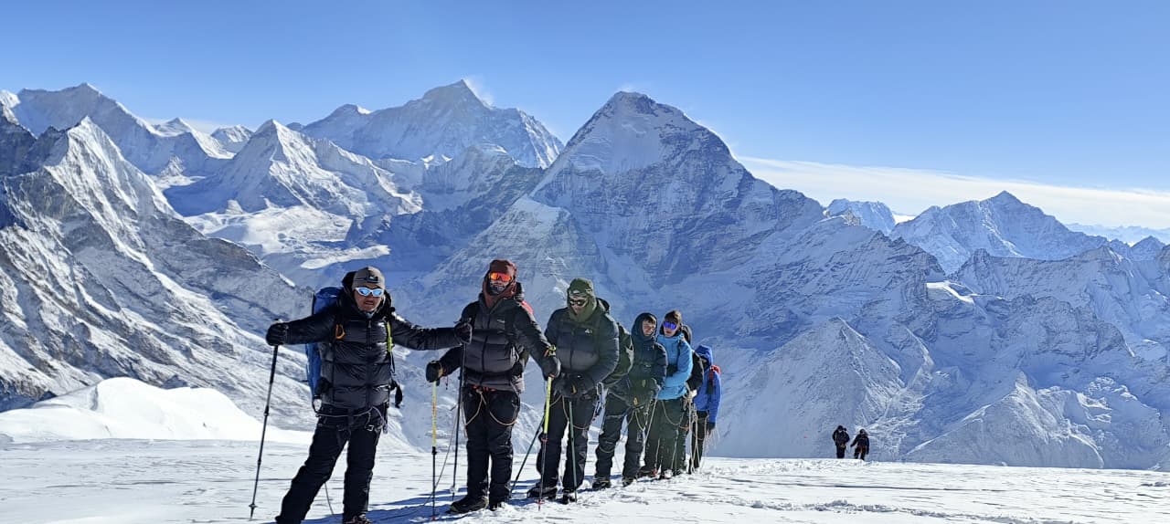
Mera Peak's approach through the Hinku Valley is not simply the road to the mountain. It is one of the genuinely remote and beautiful trekking routes in all of Nepal, and for many climbers it ranks among the most memorable parts of the entire expedition. The Hinku Valley sees a fraction of the foot traffic that moves through the Khumbu's main Everest corridor, which means the trail passes through a landscape that has not been shaped by mass tourism. The forests are denser, the Sherpa and Rai villages are smaller and more self-contained, the wildlife is less habituated to human presence, and the overall atmosphere is one of genuine high-altitude wilderness.
The standard approach begins in Lukla at 2,860 metres, the same starting point used for Everest Base Camp and Island Peak expeditions. From Lukla, the route heads south and then east, diverging sharply from the busy EBC trail corridor. The first few days pass through villages including Paiya, Pangkongma, and Nagindingma, where rhododendron forests and Sherpa farmsteads characterise the landscape. Pangkongma La, a ridge crossing at roughly 3,174 metres, provides the first views south toward the Hinku drainage and the distant silhouette of Mera Peak itself.
Below Pangkongma La, the trail drops into the Hinku Valley proper and follows the Hinku Khola river northward. The valley walls are steep and forested in the lower sections, with the trail running along the western bank of the river through varying terrain of jungle, bamboo groves, and rocky stream crossings. The permanent settlements thin out quickly above Kothe at 3,600 metres, and from Tangnag at 4,350 metres onward, the landscape transitions into the open alpine moorland and eventual glacial terrain that defines the upper valley. Khare, at just over 5,000 metres, is the last seasonally-occupied settlement on the approach and serves as the effective base camp for the expedition. Teahouses in Khare operate during the spring and autumn climbing seasons but close through the winter months. Above Khare, the terrain is fully glaciated and all accommodation is in expedition tents.
The alternative approach via the Zatrwa La pass at 4,600 metres bypasses the lower Hinku Valley and shortens the overall itinerary by several days, but it sacrifices the best acclimatisation profile and some of the most beautiful trekking on the route. Experienced operators generally recommend the full Hinku Valley approach for its superior altitude graduation and for the quality of the experience it provides. Groups that cut the approach short by using the Zatrwa La from Lukla frequently arrive at Khare insufficiently acclimatised, which is reflected in higher rates of altitude symptoms and lower summit success.
Technical Difficulty: An Honest Assessment
Calling Mera Peak non-technical is accurate in the strict mountaineering sense but can create a misleading impression for people planning their first high-altitude climb. The route does not have vertical ice pitches, no belayed rock climbing is required, and the glacier terrain is less broken than what you encounter on Island Peak. What it does require is consistent competence on the following: walking in crampons on moderately angled snow for sustained periods, basic crevasse awareness and rope team protocols on glaciated ground, use of a jumar on a fixed rope for the final 50-metre headwall section below the summit, and the physical and mental endurance to sustain ten to twelve hours of effort at above 5,000 metres starting between 3:00 and 5:00 in the morning.
The summit push begins from high camp at approximately 5,780 metres. From there, the route crosses the Mera La glacier, a broad snowfield that requires rope team travel in conditions of poor visibility or when crevasse coverage is significant. Above the snowfield, the terrain steepens as it approaches the final ridge. A short but steep section of around 50 metres uses fixed ropes and requires jumar technique. The summit of Mera North sits at the top of this final rise, with a view that expands from nothing to the full 360-degree panorama of the Himalayan chain in the space of a few steps.
The most important technical skill on Mera Peak is not physical technique but pacing. The altitude at summit elevation, roughly 47 percent of available oxygen at sea level, makes any sustained effort far more demanding than it would feel at sea level. Guides consistently report that the primary cause of failed summits is not a lack of technical ability but an inability to manage pace effectively in the early hours of summit day, when the pre-dawn cold and the excitement of the final push combine to encourage a speed that the body at altitude cannot sustain. Walking slowly, breathing deliberately, and trusting the guide's pace-setting are the most practically useful things a first-time climber can do on Mera Peak summit day.
The Ascent Step by Step: Khare to the Summit
From Khare to Base Camp
Khare sits at just over 5,000 metres and is the logical staging point for the days before summit. Operators structure the time in Khare differently, but a standard approach includes at least one full acclimatisation day with a guided training session on crampon use, ice axe technique, jumar operation, and rope protocols. This session takes place on the lower glacier above Khare and typically lasts four to six hours. The objective is twofold: give climbers practical experience with the equipment before they need it under fatigue and cold at altitude, and push the body to a slightly higher altitude during the day before returning to sleep lower, which accelerates the acclimatisation process.
The short hike from Khare to base camp at approximately 5,350 metres crosses the lower glacier moraine and then the toe of the Mera Glacier itself. Crevasses are present on this approach and rope travel begins here. The base camp is set on a relatively flat snow shelf with views north toward the summit ridge and east toward the remote terrain of the Hongu basin. Expedition tents are pitched here by the cook crew ahead of the group's arrival, and the camp includes a sleeping tent, kitchen tent, and toilet tent as standard in properly organised expeditions.
Base Camp to High Camp
High camp at approximately 5,780 metres is reached by a half-day carry from base camp over the upper glacier. The ascent is generally straightforward in good conditions, following a well-marked route on consolidated snow. Crevasse zones require careful navigation and guidance from the lead Sherpa. The high camp sits on a flat snow platform with expansive views to the south and west, and the full scale of the upper Hinku Valley and the peaks surrounding it becomes visible from here in a way that is not apparent from lower down. Summit day begins from this camp, usually with a wake-up between 2:00 and 3:00 AM.
High Camp to Summit
Departure from high camp in the pre-dawn hours puts climbers on the glacier by headlamp. The route follows the upper snowfields of the Mera La toward the base of the summit ridge. In good snow conditions, this section moves at a steady walking pace with crampons providing secure purchase on the compacted surface. The glacier here is wide and open, and weather can change quickly: a clear sky over the camp can become obscured by cloud moving in from the south within an hour, so the standard turnaround protocol of reaching the summit no later than mid-morning is enforced by experienced guides regardless of how conditions feel at departure.
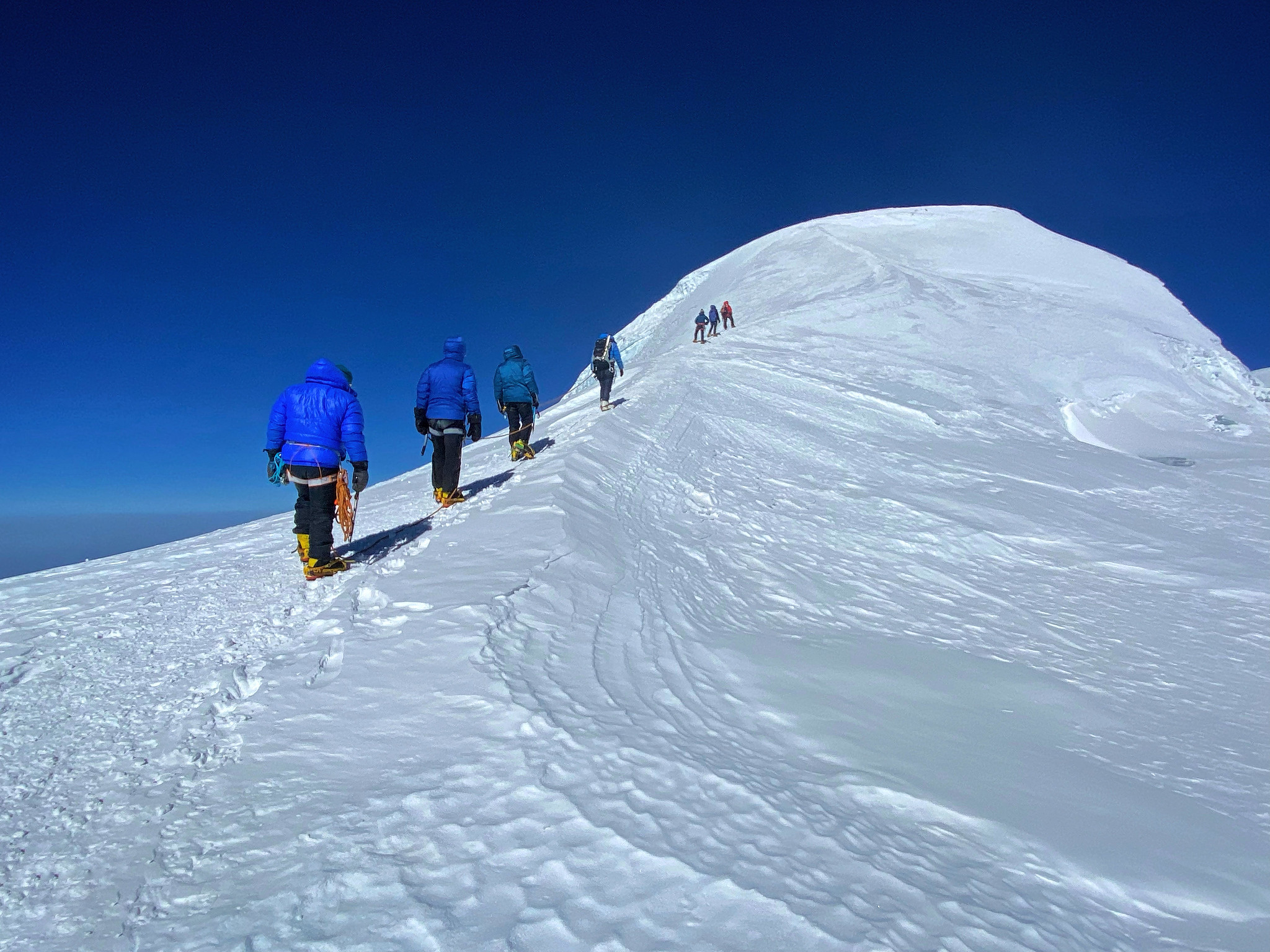
The final approach steepens significantly below the summit. Fixed ropes installed by the lead Sherpa cover the 50-metre near-vertical section that guards the summit platform. Jumars clip to the rope, and the final push to the top requires sustained effort on cold, hard snow. Most climbers arrive at the summit of Mera North between sunrise and 9:00 AM. The summit itself is a broad, relatively flat snow plateau rather than a knife-edged ridge, which means there is space to stand, look around, photograph, and absorb the view without the anxiety of an exposed position.
The panorama from the Mera North summit is, by any reasonable measure, among the finest available from any single point below 7,000 metres on Earth. Everest stands to the northwest, its characteristic pyramid shape unmistakable even at this distance. Lhotse's massive south wall is visible to the north of Everest. Makalu to the east presents its striking five-ridged form. Cho Oyu, the sixth-highest peak in the world, is visible to the northwest beyond Everest. Kangchenjunga, 140 kilometres to the east in the Sikkim-Nepal border region, anchors the eastern horizon. On a clear October morning, the full arc from Kangchenjunga through Makalu, Everest, Lhotse, and Cho Oyu is visible simultaneously from a single standing position. This kind of summit view is what people mean when they say Mera Peak delivers an experience that exceeds what its technical grade would suggest.
Gear List: What You Need for Mera Peak
Gear for a Mera Peak expedition divides into two practical categories: the equipment used during the multi-day approach trek through the Hinku Valley, and the technical mountaineering gear deployed from Khare upward. The approach gear is broadly consistent with what any serious multi-day Himalayan trekker would carry, while the technical gear is specific to glacier and snow climbing above 5,000 metres.
For the approach trek, the essential items are: waterproof trekking boots with good ankle support, a layered clothing system comprising moisture-wicking base layers, a mid-layer fleece or synthetic insulated jacket, and a waterproof outer shell, trekking poles, a sleeping bag rated to at least minus fifteen degrees Celsius (the upper valley and camp nights demand this), a quality headlamp with spare batteries, sunglasses with a protection rating of at least UV 400 and wraparound coverage, sunscreen with SPF 50 or higher (UV intensity at altitude is significantly greater than at sea level), and a daypack of 20 to 30 litres for daily use while the main duffel travels with the porter.
The technical mountaineering gear required above Khare includes: double or single mountaineering boots rated to minus 40 degrees Celsius (boots used on Mera Peak must keep feet functional through pre-dawn starts at high camp where temperatures with wind chill can reach minus 20 to minus 30 degrees), twelve-point technical crampons compatible with your boots, a climbing harness, a jumar (ascending device), at least three locking carabiners, a belay device, a climbing helmet, and an ice axe. Gaiters covering the boot and lower leg prevent snow ingress on the glacier sections. Expedition-weight gloves or mitts are essential for the summit push; standard trekking gloves are insufficient at summit temperatures. Down summit mitts over a liner glove provide the standard combination.
Most technical gear is available for rent in Kathmandu's Thamel district and at some teahouses in Khare during the climbing season. Renting makes sense for a single expedition. The one item worth purchasing rather than renting, as with Island Peak, is mountaineering boots. Rented boots in Kathmandu are often poorly fitted, and poorly fitted boots at 6,000 metres produce blisters that can genuinely stop a summit attempt. If you plan any further Himalayan climbing after Mera Peak, buying quality mountaineering boots is a sound long-term investment. They should be broken in over multiple weeks of loaded hiking before the expedition departs.
Permits and Official Requirements
Three permits are needed to climb Mera Peak. The Mera Peak Climbing Permit, issued by the Nepal Mountaineering Association, is the primary access authorisation and the one that defines the season and cost structure. As of 2025, the permit costs approximately USD 250 per person for the spring season (February through May) and around USD 125 per person for the autumn season (September through November). The winter rate (December through January) is around USD 125 per person, though commercially organised expeditions in winter are rare. The NMA also charges a garbage deposit of approximately USD 250 per expedition group (not per person), which is refundable on return of a specified quantity of waste from the mountain. Permit fees are subject to annual adjustment and should be confirmed directly with your trekking operator.
The Sagarmatha National Park entry permit is required because the approach from Lukla passes through Sagarmatha National Park. This permit costs USD 30 per person. A local area permit, sometimes described as the Khumbu Pasang Lhamu Rural Municipality permit, is required for trekkers in the Khumbu zone and costs approximately USD 20 per person. Some itineraries also pass through the Makalu Barun National Park buffer zone, which requires the Makalu Barun National Park entry permit at approximately USD 30 per person (approximately NPR 3,000). All permits are organised by your registered trekking agency in Kathmandu before the trek departs and are checked at multiple points on the approach including Lukla, Kothe, and Khare.
A licensed Nepali guide is required by regulation. Independent foreign trekkers cannot climb any licensed trekking peak in Nepal without a registered guide. Beyond the legal requirement, the Hinku Valley's trail is less clearly marked than the Everest Base Camp corridor, and the glacier terrain above Khare is genuinely hazardous without someone who knows the route well. The guide also handles the permit inspections, teahouse bookings, cook crew logistics, and the dozens of small operational decisions that make the difference between a smoothly-run expedition and a stressful one.
Costs: What to Budget for a Mera Peak Expedition
A fully guided Mera Peak expedition from a registered Kathmandu operator runs approximately USD 2,200 to USD 3,500 per person for a standard 16 to 18 day itinerary. This range reflects differences in group size, the inclusion or exclusion of Kathmandu hotel nights, domestic flight type (regular aircraft versus helicopter for the Kathmandu-Lukla leg), and the overall service standard of the operator. Packages at the lower end of the range typically use standard aircraft for Lukla flights, include only basic teahouse accommodation in Kathmandu, and may use a single guide for a larger group. Packages at the higher end include helicopter transfers to Lukla (which avoids the significant delay risk associated with weather-dependent small aircraft operations at Lukla), smaller group sizes or private guiding ratios, and better Kathmandu hotels.
Breaking costs into components gives a clearer picture. The Mera Peak climbing permit runs USD 125 to 250 depending on season. National Park and local area permits total around USD 80. A licensed guide earns USD 35 to 50 per day. Porter fees run USD 20 to 30 per day per porter. One porter typically serves one to two trekkers. Cook crew fees for the camping section above Khare are additional. Domestic flights between Kathmandu and Lukla cost approximately USD 180 to 220 per person each way by regular aircraft. Teahouse accommodation costs USD 10 to 30 per night depending on altitude and season. Meals at teahouses run approximately USD 35 to 45 per day. Camping costs above Khare include tent hire, cooking equipment, and food preparation by the cook crew, all of which are bundled into most package prices.
Costs that fall outside most package prices and must be budgeted separately: international flights to Kathmandu, Nepal visa fees (USD 50 for 30 days on arrival), travel insurance (mandatory and must specifically cover climbing to 6,476 metres and emergency helicopter evacuation from altitude), personal gear purchases and rentals, tips for guides, porters, and cook crew (a meaningful part of these workers' annual income and strongly expected), and personal trail expenses including Wi-Fi fees, battery charging, extra snacks, hot showers above base level, and any optional alcoholic drinks. A realistic total budget including international flights from Europe or North America runs USD 4,500 to USD 7,000 depending on flights, gear needs, and personal spending habits.
Best Time to Climb Mera Peak
The two viable climbing windows follow Nepal's standard high-altitude trekking seasons. Spring runs from March through May, with April considered the prime month by most experienced operators. Post-monsoon autumn runs from late September through November, with October being the most consistently reliable single month across weather, visibility, and trail conditions.
Spring on Mera Peak means longer daylight hours, rising temperatures at lower altitudes that make the Hinku Valley approach comfortable, and the visual spectacle of rhododendron forests in bloom through the lower and mid-altitude sections of the trail. Snow conditions on the upper glacier tend to be more consolidated and predictable in spring than in autumn, when the monsoon's residual snowfall can leave varying snow quality on the summit slopes. The downside of spring is that it is the busier climbing season, which means Khare teahouses are more crowded and competition for cook crew and porter availability is higher for late bookings.
Autumn offers some of the sharpest mountain visibility of the year. The monsoon scrubs dust and haze from the atmosphere, and October in particular regularly produces the kind of crystal-clear morning conditions that make the five-eight-thousander panorama from the summit genuinely overwhelming. Temperatures are falling through the season, and by late November the upper valley nights are seriously cold. Summit day temperatures at 6,476 metres in October with wind chill can reach minus 20 to minus 25 degrees Celsius; in November that figure drops further. November also sees fewer climbing teams in the Hinku Valley than October, which many climbers find preferable for the quieter atmosphere.
Winter from December through February is technically possible but not commercially standard. Temperatures at high camp and on the summit approach are extreme, with wind chill at summit elevation reaching minus 30 degrees Celsius or below. The Hinku Valley teahouses above Kothe and Tangnag close for the season, meaning the entire approach above the lower valley must be done on a camping basis. For climbers with genuine cold-weather expedition experience, late December and February can offer exceptional conditions on the mountain itself, but these expeditions are not suitable for beginners and require significantly more equipment than a standard season ascent.
Acclimatisation: Why Mera Peak Demands More Respect Than Its Grade Suggests
The altitude of Mera Peak is the single most important factor separating it from most other beginner-level Himalayan objectives. At 6,476 metres, the available oxygen per breath is approximately 46 percent of what is available at sea level. For reference, the Everest Base Camp trek peaks at 5,364 metres at the camp itself and 5,545 metres at Kala Patthar, both meaningfully lower than Mera's summit. Island Peak's summit is 6,189 metres, also lower. The extra 300 to 500 metres of altitude gain between those objectives and Mera Peak creates a physiological step change that should not be underestimated.
The standard acclimatisation protocol for Mera Peak requires a gradual ascent from Lukla over a minimum of nine to eleven trekking days before reaching Khare. The general high-altitude guideline of sleeping no more than 300 to 500 metres higher per night above 3,000 metres is followed in the itinerary structure, though the geography of the Hinku Valley and the spacing of teahouses means some stages involve larger daily altitude gains than the ideal. This is why the acclimatisation day in Khare, and the day-hike-higher-sleep-lower approach used on training days, are so important. Sleeping at 5,780 metres in high camp on the night before summit is a significant altitude exposure. Bodies that have not been properly prepared for that sleeping altitude typically produce poor oxygen saturation readings and symptomatic AMS through the night, which directly affects summit day performance and increases risk.
The success rate data from Mera Peak bears this out. A 2022 season analysis found that the overall success rate across all operators was just over 50 percent, with altitude sickness and insufficient acclimatisation being the primary cause of failed attempts. Well-run expeditions with conservative itineraries and mandatory rest days report success rates of 80 percent or above with the same client profiles. The difference is almost entirely acclimatisation management. Choosing an operator whose itinerary includes a genuine acclimatisation day in Khare, pre-summit training at altitude, and a buffer summit day for weather delays is not a comfort preference; it is a direct determinant of whether you reach the top.
Standard AMS prevention protocols apply: ascend gradually, hydrate consistently with three to four litres of water per day, monitor symptoms honestly with your guide, and carry a pulse oximeter for objective blood oxygen readings. Readings below 85 percent at rest above 4,000 metres warrant a rest day or descent decision. Garlic soup, widely available in Hinku Valley teahouses, is a traditional high-altitude remedy with some evidence of benefit and no harm; many experienced Himalayan guides recommend it from the first day in the valley. Acetazolamide (Diamox) at 125 to 250 mg twice daily can be used prophylactically by climbers with a history of altitude sensitivity, after discussion with a physician, beginning 24 hours before reaching the target altitude.
Physical Training: How to Prepare for Nepal's Highest Trekking Peak
The physical demands of Mera Peak differ from those of Island Peak in one important respect: the technical sections are shorter and less strenuous, but the sustained duration of effort is greater. Summit day from high camp involves approximately eight to ten hours of steady walking at altitude with relatively little of the intense crampon-and-jumar effort that characterises Island Peak's headwall. This means cardiovascular endurance over long duration is the primary physical requirement, rather than the short bursts of intense muscular effort that other peaks demand.
Training should start at least 12 to 15 weeks before departure. The structure recommended by experienced Himalayan guides is approximately 80 percent low-intensity aerobic work and 20 percent higher-intensity sessions. In practice this means four to five sessions per week of running, cycling, swimming, or hiking at a conversational pace, plus one or two sessions per week of interval work or hill repetitions. The most directly applicable training activity is long-day hiking on uneven terrain with a loaded pack. Weekend hikes of six to eight hours carrying eight to ten kilograms simulate the approach days in the Hinku Valley closely enough to provide both physical preparation and a useful personal benchmark. If you can complete two consecutive days of six-hour loaded hiking without significant muscle soreness or fatigue on the third morning, your endurance baseline is broadly appropriate for the Mera Peak approach.
High-altitude training is the one component that cannot be replicated at low elevation. If you have access to mountains above 3,000 metres before departing for Nepal, even one or two overnight trips sleeping at altitude provides useful physiological preparation. In the absence of local mountains, altitude simulation tents (available for hire in some cities) provide a partial substitute, though results vary. The most practical substitute for many trekkers is simply ensuring the Nepal approach itinerary is long enough to provide genuine acclimatisation before arriving at Khare.
Leg strength training should run alongside the cardiovascular work. Squats, step-ups, lunges, and Bulgarian split squats address the quad, glute, and calf demands of steep descent and ascent. Descent on Mera Peak is long and sustained on tired legs, and weak quads on the descent contribute to knee stress and slower recovery. A basic core routine of planks, dead bugs, and single-leg balance exercises builds the stability needed for walking on uneven glacier terrain with crampons.
Mera Peak vs Island Peak: A Practical Comparison
The question of whether to attempt Mera Peak or Island Peak first comes up repeatedly in planning conversations, and the right answer depends on what a person is actually looking for from their first Himalayan climb.
Mera Peak is higher, at 6,476 metres against Island Peak's 6,189 metres. The altitude difference matters physiologically and is the primary reason Mera demands a more conservative acclimatisation profile. On the technical side, Island Peak is more demanding: its glacier crossing, near-vertical headwall, and exposed summit ridge require more active mountaineering technique than Mera's sustained glacier walk. Island Peak's summit day is shorter in elapsed time but more technically concentrated; Mera's summit day is longer in duration but more physically manageable in a technical sense.
For a trekker whose primary goal is reaching the highest summit accessible without full expedition mountaineering experience, Mera Peak is the objective. For a trekker who wants a genuine introduction to the technical skills of glacier and headwall climbing as preparation for future harder routes, Island Peak is the better investment. Many operators offer a combined expedition doing Mera and Island Peak in sequence on an 18 to 24-day itinerary, which resolves the question by delivering both. Doing Mera first provides the altitude acclimatisation base that makes Island Peak's summit day more manageable.
Why the Hinku Valley Experience Sets This Climb Apart
The commercial Himalayan trekking world has a well-documented crowding problem on its most famous routes. The Everest Base Camp trail between Lukla and the base camp hosts tens of thousands of trekkers per season. The busiest stretches near Namche Bazaar and Tengboche can feel more like a managed tourist corridor than a mountain trail. The Hinku Valley is the geographic opposite of that experience.
Above the lower Hinku settlements, the trail has no permanent villages and very few seasonal teahouses. The river valley runs between steep forested walls with the occasional snow peak visible at the head of each side drainage. Wildlife in the conservation area includes Himalayan tahr, musk deer, and, in the forested lower sections, red panda and common langur. The birding is excellent throughout the lower valley. The Sabai Tso glacial lake, visible from the lateral moraine above Tangnag, is one of the most beautiful alpine lakes in eastern Nepal and sits well off the standard tourist circuit.
The cultural dimension of the approach is also distinct. The villages in the lower Hinku and Dudh Kosi drainages are populated by Rai and Sherpa communities whose economic relationship with trekking tourism is far less developed than in the main Khumbu corridor. The pace of life in these villages is agricultural and pastoral. When the trail passes through a village in the lower Hinku on a weekday afternoon, the people you pass are going about their own business, not catering to tourism. This quality, the sense of being a visitor in someone else's world rather than a customer in a managed experience, is one of the things that makes the Mera Peak approach genuinely different from the more heavily-trafficked Himalayan routes.
Choosing an Operator: What to Look For
The quality gap between operators running Mera Peak expeditions is significant and directly affects both summit success rates and safety margins. The most important variable is the experience and local knowledge of the lead guide. A Sherpa guide who has guided Mera Peak forty times knows the glacier's seasonal condition changes, knows which crevasse zones require extra attention in which snow conditions, and knows exactly what blood oxygen reading at Khare corresponds to a realistic summit probability. This knowledge cannot be acquired from a guidebook or a short training course.
Questions worth asking any operator before booking: How many times has your lead guide summited Mera Peak specifically? What is your guide-to-client ratio on summit day? Does your itinerary include a genuine acclimatisation day in Khare with a training session on the lower glacier? Do you carry a pulse oximeter and conduct routine monitoring from Kothe upward? What is your documented descent protocol if a client develops AMS symptoms at high camp? An operator who answers these questions specifically and confidently is operating a different kind of expedition from one whose marketing is polished but whose operational protocols are vague.
Local operators based in Kathmandu with guides from the Khumbu and Hinku regions carry practical advantages. They have existing relationships with teahouse owners along the route, which matters for confirming room availability during the busy spring season. Their cook crews know the upper valley camping sites and the water sources. Their emergency protocols are linked to helicopter evacuation companies by existing relationships that translate into faster response times when a medical situation develops. At 6,476 metres, the logistical quality of the organisation around you is not a comfort issue; it is a safety issue.
Mera Peak is, by any fair measure, a serious undertaking. It sits at nearly twice the altitude of Mont Blanc. It demands ten to fourteen days of sustained physical effort just to reach the starting point of the climb. It asks for physical preparation that begins months before departure. And it rewards all of that preparation with a summit view that includes five of the fourteen highest mountains on Earth, seen simultaneously from a point in the sky that very few people ever reach. For the right person, fully prepared and accompanied by experienced local guides, it is one of the finest mountain experiences available anywhere in the world.
About Accessible Adventure
Bringing unforgettable Himalayan adventures to everyone. Our expert guides and carefully curated experiences ensure that everyone can explore the beauty of Nepal, Tibet, and Bhutan.
Learn More