Why Choose Langtang Valley Trek, Nepal: Distance, Duration & Highlights?
Langtang Valley Trek: Nepal's Valley of Glaciers
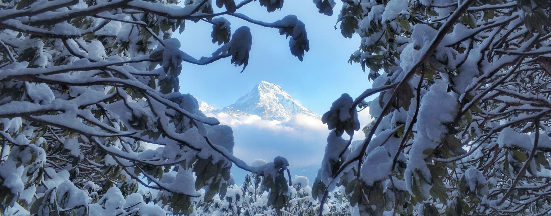
Ask most trekkers what pulled them toward Langtang and you get the same answer, worded differently each time: they wanted the Himalayas without the crowds. That's a fair summary. About 130 kilometres north of Kathmandu, sitting inside Rasuwa District, the Langtang Valley is closer to the capital than any other serious trekking region in Nepal. And yet it feels nothing like a quick getaway. The peaks here are enormous. Langtang Lirung hits 7,227 metres and dominates the northern wall of the valley like something out of a different scale entirely. Ganesh Himal, Dorje Lakpa, and Gangchempo close in from the south and east. The valley earned its nickname, the Valley of Glaciers, for obvious reasons.
You walk in from subtropical forest at the valley floor, climb through rhododendron and oak woodland in the middle stretch, and end up at Kyanjin Gompa: a stone village at 3,870 metres where yaks graze in summer and glaciers sit close enough that you can walk to the moraine in twenty minutes.
The standard route runs somewhere between 65 and 80 kilometres round trip, depending on whether you go up Kyanjin Ri (4,773m) or push to Tserko Ri (4,984m). Most trekkers take seven to ten days, starting and ending with the drive between Kathmandu and Syabrubesi, the gateway town at 1,550 metres where the Langtang River meets the Bhote Koshi. Along the way you pass through Lama Hotel, Langtang Village, Ghodatabela, and a handful of smaller settlements that have been here for centuries. The trail is moderate, genuinely. First-time Himalayan trekkers who've put in some training complete it regularly. So do experienced trekkers looking for a compact, high-quality route they can finish in a week without domestic flights or extensive planning.
What separates Langtang from its more famous counterparts is cultural weight. The Tamang people live here. Their identity is rooted in Tibetan Buddhism in a way that isn't decorative. The monasteries, mani walls, and festivals along the route aren't staged for visitors. They're simply daily life at altitude, and they carry a very different quality from what you encounter on routes built primarily around tourist infrastructure.
If you're researching this trek: the guide below covers the itinerary, what's distinctive about each day, the realistic costs, how to prepare, where to sleep and eat, altitude management, and the questions most people ask before they go. Book ahead for spring and autumn. Carry cash out of Kathmandu because the trail has no ATMs after Trishuli Bazaar. And hire a licensed local guide. That's the short version.
Why Choose the Langtang Valley Trek: Seven Defining Highlights
You Can Get Here Without a Domestic Flight
This matters more than it sounds. Most high-altitude trekking in Nepal involves a domestic flight to a mountain airport that runs on weather windows and routinely delays for days. Lukla is the obvious example. Langtang is different. The drive from Kathmandu to Syabrubesi runs six to eight hours on a road that passes through the Trishuli River valley, climbs through gorges, and deposits you at the trailhead the same day you leave the city. You leave Kathmandu at six in the morning, you're in Syabrubesi by early afternoon, and you start walking the next day. For trekkers with ten to twelve days in Nepal, that kind of efficiency is worth more than it might appear on paper.
The Trails Are Quiet, But the Views Are Not
Langtang doesn't draw the numbers Everest and Annapurna do. During October and November or March and April, you'll encounter other trekkers at teahouses and on the path. But the sense of having space remains. The trail through rhododendron forest or along the river runs quiet on most days. And the panoramas from Kyanjin Ri and Tserko Ri are not consolation prizes for avoiding more famous routes.
From Tserko Ri at just under 5,000 metres, you're looking at Langtang Lirung in full, the Langtang Glacier spread across the valley floor below you, Dorje Lakpa, Shishapangma across the Tibetan border, and ranges receding in every direction. These are serious views. They compete directly with the best vantage points in Nepal, full stop.
The Tamang Culture Is Real and It's Everywhere
The Tamang are the dominant ethnic group in this valley, and their identity is inseparable from Tibetan Buddhism. Every settlement on the trail has at least one monastery or gompa. Mani walls line the path: flat stones carved with mantras, stacked into structures that have been building for generations. At Kyanjin Gompa, you can sit in on morning or evening puja at one of the oldest monasteries in the region: monks chanting, incense smoke, lamplight. The teahouses are family businesses. The conversations you have across a dinner table here carry something that more commercialized routes have mostly lost. The Tamang communities in this valley have maintained their practices through the 2015 earthquake, economic pressure, and everything the twenty-first century has thrown at them. That continuity shows.
The National Park Is Genuinely Wild
Langtang National Park was Nepal's first Himalayan national park, established in 1976. It covers 1,710 square kilometres of terrain that ranges from subtropical valley floor to glaciers above 5,000 metres. Red panda, snow leopard, Himalayan black bear, musk deer, tahr, and serow all live within the park boundaries. More reliably visible are the birds: over 250 species have been recorded here. The vegetation layers are visually dramatic across the course of a week's walking: bamboo and oak at the bottom, rhododendron forest through the middle reaches (spectacular in spring bloom), then open alpine meadow and scrub above the treeline. Walking through all of it in sequence gives you a complete picture of Himalayan ecology that can't be shortcut.
There's a Yak Cheese Factory at 3,870 Metres
Kyanjin Gompa has a functioning cheese factory. It's been operating since the 1950s using techniques introduced through a Swiss development programme, and it survived the 2015 earthquake and the rebuilding that followed. The cheese is made from yak milk collected from herds grazed on the high pastures surrounding the village each summer. Dense, slightly sharp, and genuinely good. Buy some before you descend. It keeps well and makes a far better souvenir than anything from a Thamel shop.
The Difficulty Level Is Honest
This is a moderate trek. Not a walk, but also not a climb. Daily walking runs five to seven hours. Maximum overnight altitude is Kyanjin Gompa at 3,870 metres, with optional day hikes pushing to 4,773 and 4,984 metres. No technical skills, no ropes, no crampons required. What the route does need is cardiovascular preparation, a genuine respect for what altitude does to the body, and the discipline to follow the itinerary rather than push the schedule. First-time Himalayan trekkers finish this route regularly, and so do people in their sixties who've been hiking all their lives.
Your Money Goes Directly to Families Who Rebuilt From Almost Nothing
The April 2015 earthquake and the landslide it triggered destroyed Langtang Village and killed over 200 people. The community rebuilt. The teahouses and lodges along the trail today are largely products of that recovery effort. When you eat at a family-run teahouse, hire a local guide, and stay in a village lodge, that money goes into households that reconstructed their livelihoods from scratch. This is not a marketing line. It is economic reality. Trekking in Langtang remains one of the most direct ways an international visitor can put money into Nepali mountain communities.


