Why Choose Gokyo Lakes Trek with Renjo La Pass?
The Khumbu Without the Crowds, and a Lot More Besides
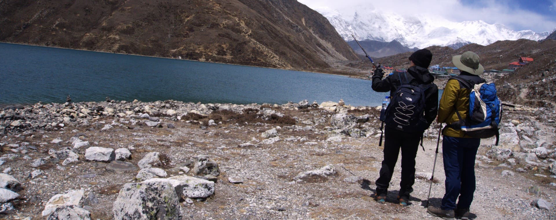
The Everest Base Camp route is one of the most walked trails on the planet. In October, the path between Namche Bazaar and Tengboche can feel more like a queue than a wilderness walk. The Gokyo Lakes Trek with Renjo La Pass takes you into the same Sagarmatha National Park, through the same Sherpa villages, and under the same mountain skyline, but along a valley that draws a fraction of the base camp traffic. The Gokyo Valley runs north from the main Khumbu corridor into a landscape of glaciers, moraine lakes, and high ridgelines that most visitors flying into Lukla never reach.
The centerpiece of this 14-day route is the Gokyo Lakes system: a chain of six sacred turquoise lakes sitting on the lateral moraine of the Ngozumpa Glacier, the longest glacier in Nepal. The third and most prominent lake, Dudh Pokhari, sits at 4,700 meters and reflects the surrounding peaks in its still surface on calm mornings. The village of Gokyo occupies a narrow flat section above the lakeshore and serves as the base for two defining days of the trek: the climb of Gokyo Ri at 5,360 meters, and the crossing of Renjo La Pass, also at 5,360 meters.
The Renjo La crossing is what separates this route from a simple out-and-back valley trek. Rather than returning the way you came, the pass takes you west over a high rocky col with one of the finest views of the Everest massif available anywhere in Nepal, and drops you into the Bhote Kosi valley toward Lumde before looping back to Namche. The circuit quality of the route gives the full 14 days a narrative arc: you walk in, you see the lakes and the glacier, you climb the ri, you cross the pass, and you come back a different way. It is a complete journey rather than a repeated corridor.
What Makes This Trek Genuinely Different
Three specific features set this route apart from the standard Everest region options. The first is the Ngozumpa Glacier. Nepal's largest glacier fills the western side of the Gokyo Valley and is visible in its full scale from the lakeshore and from Gokyo Ri. The scale is difficult to communicate in photographs: the glacier is 36 kilometers long and up to 1.5 kilometers wide in sections, and walking beside it on the moraine gives a sense of glacial geography that the more visited Khumbu Glacier does not offer from the same proximity.
The second is Gokyo Ri itself. At the same 5,360-meter elevation as Renjo La Pass, the summit of Gokyo Ri delivers a 360-degree panorama that many experienced trekkers and mountaineers rate above the view from Kala Patthar on the Everest Base Camp route. Cho Oyu at 8,201 meters dominates the northwestern skyline. Everest, Lhotse, and Makalu are visible to the northeast. The full length of the Ngozumpa Glacier unrolls below. The climb from the Gokyo village takes two to three hours and is on a trail rather than technical terrain.
The third distinguishing feature is the Renjo La crossing itself. The pass at 5,360 meters offers a view of Everest that many photographers and trekkers consider the finest single mountain composition available from a trekking-accessible point in Nepal: the summit of Everest framed between the rocky walls of the pass, with the Gokyo Valley and its lakes visible behind, and the Bhote Kosi drainage opening ahead. The crossing is demanding, particularly on the descent side, but is non-technical and well within the reach of a properly prepared trekker.
Highlights of the Gokyo Lakes Trek with Renjo La Pass
-
Six Sacred Gokyo Lakes: A chain of six glacially fed lakes on the moraine of the Ngozumpa Glacier, considered sacred in both Hindu and Buddhist traditions, with the third lake Dudh Pokhari at 4,700 m as the visual centerpiece of the system.
-
Gokyo Ri (5,360 m): One of the finest panoramic viewpoints in the Khumbu, with simultaneous views of Cho Oyu, Everest, Lhotse, Makalu, and the full length of the Ngozumpa Glacier from a single summit accessible on a standard trekking trail.
-
Renjo La Pass (5,360 m): The high crossing that turns the Gokyo valley approach into a proper circuit, with the most celebrated Everest-framed composition in the Himalayan trekking landscape on the eastern side of the pass.
-
Ngozumpa Glacier: Nepal's longest glacier at 36 kilometers, running the full length of the western side of the Gokyo Valley and visible in dramatic scale from the lakeshore, Gokyo Ri, and the moraines above the upper lakes.
-
Namche Bazaar (3,440 m): The commercial and cultural capital of the Khumbu, a horseshoe-shaped town with bakeries, gear shops, a Saturday market, the Sherpa Museum, and the first clear mountain views on the route.
-
Phortse Thanga and the Gokyo Corridor: The quieter, less-traveled approach trail along the western side of the valley that connects Namche to the Gokyo system via Phortse Thanga and Machhermo, significantly less busy than the parallel EBC corridor.
-
Cho Oyu (8,201 m): The sixth-highest mountain on earth and the dominant peak of the Gokyo skyline, massively visible from the lakeside, the glacier moraine, and from the summit of Gokyo Ri.
-
Machhermo (4,470 m): A small settlement famous among wildlife enthusiasts as the location of a 1998 Yeti encounter reported by local residents, and a good acclimatization stop before the final push to Gokyo.
-
Two Acclimatization Days: A strategically placed rest day at Namche Bazaar and a second acclimatization day at Gokyo that doubles as the Gokyo Ri climb day, building altitude tolerance before the two high-point days.
-
Kathmandu Heritage Sightseeing: A Kathmandu contingency and sightseeing day on Day 13 covering the city's main heritage sites and serving as a practical buffer for the weather-dependent Lukla return flight.
Detailed Journey Breakdown
Kathmandu and the Lukla Flight
Day 1 covers arrival and preparation. Day 2 begins with the 35-minute mountain flight from Kathmandu to Lukla, landing at Tenzing-Hillary Airport at 2,840 meters, followed by a three to four-hour walk down the Dudh Kosi River to Phakding. Day 3 is the demanding but rewarding push to Namche Bazaar, with the trail entering Sagarmatha National Park at the Monjo gate and crossing the Hillary Suspension Bridge before the long climb to the horseshoe town at 3,440 meters.
Namche Acclimatization and the Gokyo Approach
Day 4 is the first acclimatization day at Namche, used for a hike to the ridge above town and the Khumjung area, giving the body its first high-altitude stimulus before the proper ascent begins. Day 5 departs from Namche on the quieter western corridor via Phortse Thanga rather than the busy EBC route, immediately entering a different quality of trail experience. Days 6 and 7 continue north through Machhermo and up the valley to Gokyo.
Gokyo: Lakes, Glacier, and Gokyo Ri
Day 8 is the second acclimatization day, used for the Gokyo Ri climb. The ascent to 5,360 meters from the village takes two to three hours on a steep but clear trail. The summit view justifies the effort completely. The lakes, the glacier, and the surrounding 8,000-meter peaks combine in a panorama that regularly appears in lists of the finest mountain viewpoints in the world. The afternoon back at the lake at 4,790 meters is for rest and recovery before the pass day.
Renjo La and the Return Circuit
Day 9 is the Renjo La crossing day. The climb from Gokyo to the 5,360-meter pass is a sustained three to four-hour effort on rocky terrain with some snow in early season. The view from the pass top is the photographic centerpiece of the entire trip. The descent to Lumde takes another three to four hours on a steep and rocky trail. Days 10 and 11 retrace the valley south via Namche to Lukla for the return flight on Day 12.


