
Why Choose Arun Valley to Everest Base Camp Trek?
The Arun Valley to Everest Base Camp Trek is a long-distance, high-altitude trekking route in northeastern Nepal that links the subtropical depths of the Arun River corridor with the iconic glacial terrain of Khumbu. Unlike the standard Everest Base Camp trek, which begins with a flight directly into Lukla at 2,860 metres, this route starts at Tumlingtar (470 m) in the Sankhuwasabha district and traverses an entirely different landscape before joining the familiar Sagarmatha trail. The result is an extended journey that passes through the edge of the Makalu-Barun National Park, crosses several remote mountain passes, visits Rai and Sherpa villages that see very few foreign trekkers, and eventually arrives at Namche Bazaar, Tengboche, Dingboche, and Gorak Shep on the way to Everest Base Camp at 5,364 metres and the summit viewpoint of Kala Patthar at 5,550 metres. The full itinerary runs anywhere from 22 to 30 days depending on pace, acclimatisation needs, and whether optional extensions such as Gokyo Lakes or Cho La Pass are included.
The valley the route is named for is the Arun River valley, which forms part of what geologists consider the world's deepest river gorge by the measure of vertical relief from surrounding peaks to water level. The Arun River flows between Mount Everest (8,848.86 m) to the northwest and Mount Makalu (8,485 m) to the east, and the river itself is fed by glaciers in Tibet before cutting southward through the Himalayan range. In the lower sections around Tumlingtar, the climate is warm and subtropical, with tropical vegetation, terraced rice fields, banana groves, and cardamom plantations lining the trail. As elevation increases, the landscape transitions through temperate forests of oak and rhododendron into alpine scrub, moraines, and eventually the ice and rock of the Khumbu. This biodiversity is one of the defining characteristics of the route and gives trekkers a more complete picture of the Himalayan ecosystem than routes that begin at mid-altitude.
The best months to attempt the Arun Valley to Everest Base Camp Trek are March through May and September through November. Spring brings warm temperatures at lower elevations, clear skies above the snowline, and the spectacular sight of rhododendron forests in full bloom across the Makalu-Barun region. Autumn delivers the most stable weather of the year, with excellent visibility, comfortable daytime temperatures, and the festive atmosphere of Dashain and Tihar in the villages. The trek can be attempted in winter but requires careful preparation due to extreme cold and the risk of snow-blocked passes. The monsoon months of June through August are generally discouraged due to heavy rainfall, leeches on lower trails, and obscured mountain views, though some experienced trekkers do complete the route during this window. The standard package for most visitors runs 22 to 25 days and is rated moderate to challenging, recommended for trekkers who have prior multi-day high-altitude experience or are physically fit and prepared to commit to a proper acclimatisation schedule.
Why Choose the Arun Valley to Everest Base Camp Trek: 7 Highlights
1. A Genuine Off-the-Beaten-Path Approach to Everest
The standard route to Everest Base Camp via Lukla is one of the most heavily trafficked trekking corridors in Asia, particularly during the spring and autumn peak seasons. The Arun Valley approach follows the trail used by the earliest Himalayan explorers and expeditions before Lukla's airstrip was constructed in the 1960s. The first half of the route, from Tumlingtar through Chewabesi, Kartike Ghat, Gothe Bazaar, Salpa Bhanjyang, Gudel, Bung, Gaikharka, and Puiyan, passes through territory where organised trekking groups are a rare sight. Locals carry cardamom and trade goods along these paths, mule trains move supplies between villages, and the teahouses are small family-run establishments with none of the commercial bustle of Namche Bazaar. Trekkers who have already completed the classic EBC route consistently describe the Arun Valley approach as the more authentic version of the experience.
2. Biodiversity Across Multiple Ecological Zones
The elevation change on this trek is extraordinary. Starting at roughly 470 metres in the subtropical Arun River valley and climbing to 5,550 metres on Kala Patthar, the route passes through more ecological zones in a single trip than almost any other trekking itinerary in the world. The Makalu-Barun National Park alone is home to more than 650 species of birds, over 800 species of butterflies, 47 varieties of orchids, 30 species of rhododendron, and a range of large mammals including red pandas, snow leopards, musk deer, and Himalayan black bears. Birdwatchers find the middle elevations particularly productive, especially between Bung and Gaikharka where forest cover is dense and undisturbed. In spring, the rhododendron forests above Salpa Bhanjyang and along the approaches to Namche turn vivid shades of red, pink, and white. The upper Khumbu section adds the sight of yak herds grazing on alpine meadows and the haunting landscape of glacial moraines near Lobuche and Gorak Shep.
3. Cultural Richness Across Three Distinct Communities
The Arun Valley route moves through the territories of three different ethnic communities, each with its own language, festivals, architecture, and relationship to the mountains. In the lower Arun sections around Tumlingtar and Chewabesi, the majority population is Rai, one of the indigenous Kirant peoples of eastern Nepal with their own religion, oral literature, and agricultural traditions. As the trail climbs toward Bung, Gaikharka, and the Pangum La Pass, the villages shift to a mixed Rai and Sherpa character. By the time the route joins the Dudh Koshi valley at Phakding, the Sherpa community dominates, with their Tibetan Buddhist culture, whitewashed chortens, prayer flag lines strung across ridgelines, and the great monastery at Tengboche sitting above the treeline with views of Ama Dablam. This cultural gradient adds depth to the trek that no amount of altitude gain alone can provide.
4. Views of Two Eight-Thousanders in a Single Trek
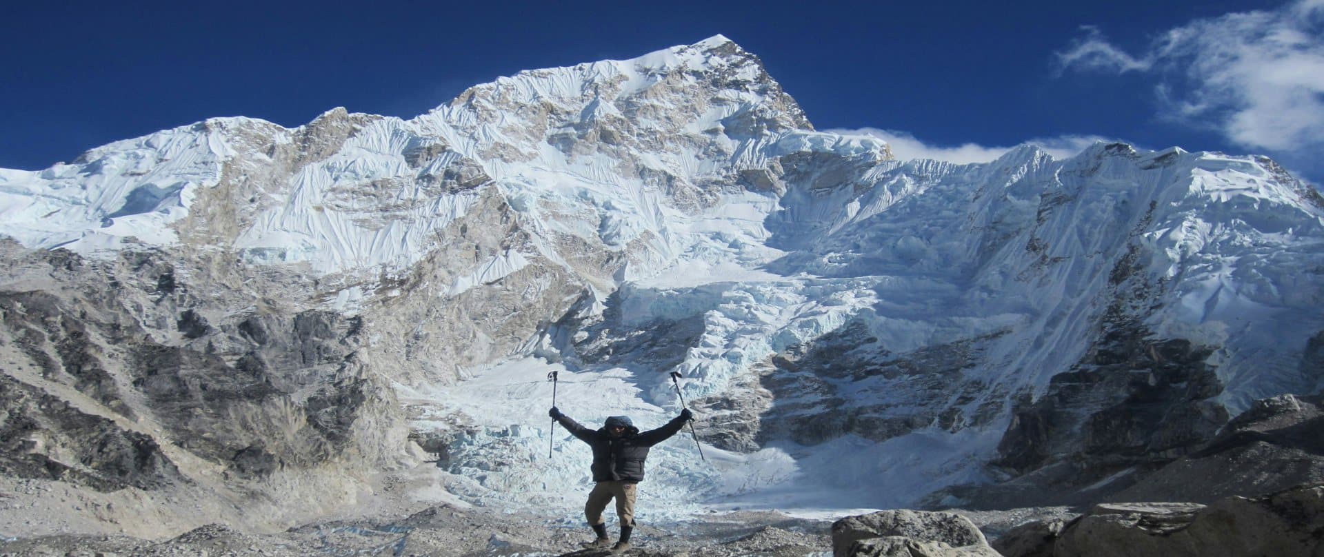
The Arun Valley to EBC Trek is unique among Himalayan routes for the extended period during which trekkers can observe both Mount Everest and Mount Makalu (the fifth-highest peak in the world at 8,485 m) in close proximity. From the high sections around Salpa Bhanjyang and Pangum La, the southern and eastern flanks of Makalu fill the horizon. As the route descends into the Dudh Koshi valley and climbs toward Namche, the Everest massif begins to reveal itself, first as a pyramid behind the ridges of Nuptse and Lhotse, and then in its full unobstructed form from Kala Patthar. The summit viewpoint of Kala Patthar at 5,550 metres provides one of the closest and most direct views of Everest's summit pyramid available without a climbing permit, with Nuptse, Lhotse, Changtse, Pumori, and Ama Dablam all visible in the same panorama.
5. The Historic Pioneers’ Route
Before the Lukla airstrip was built in the 1960s, all Everest expeditions approached the mountain on foot from the east, travelling through the Arun Valley and across the passes connecting it to the Dudh Koshi drainage. Members of the early Everest expeditions of the 1950s, including the team that made the first ascent in 1953, used variations of this route. Trekking through the same valleys and over the same passes carries a particular resonance for anyone interested in the history of Himalayan mountaineering. The trails are unchanged in character from those the pioneers walked, passing the same Rai villages, the same steep forest climbs, and the same sweeping views from the high passes that expedition diaries describe.
6. Salpa Pokhari, a Sacred Highland Lake
One of the most memorable natural landmarks on the route is Salpa Pokhari, a high-altitude lake near the Salpa Bhanjyang pass at around 3,349 metres. The lake is sacred to both Hindu and Buddhist communities throughout eastern Nepal and draws pilgrims from across the region, particularly during the month of Kartik (October to November) when a large annual fair takes place on its shores. Visiting the lake in the autumn coincides with this festival season and gives trekkers a window into a dimension of Himalayan religious life that has nothing to do with the commercial trekking industry. The area around the lake is also one of the best places on the entire route for views of Chamlang (7,321 m) and the southern flanks of Makalu.
7. A Fuller Physical and Mental Challenge
The additional length and complexity of the Arun Valley approach provide a more comprehensive preparation for the high-altitude section. Trekkers who join the Khumbu trail at Phakding after ten or eleven days of walking from Tumlingtar have already conditioned their legs and lungs through thousands of metres of daily ascent and descent. The gradual increase in elevation across the Arun section, with nights spent between 500 and 3,200 metres, gives the cardiovascular system more time to adapt than the compressed schedule of the standard Lukla-based itinerary. Many trekkers report that the transition into the Khumbu feels manageable precisely because they have had this extended physical preparation. For those seeking the fullest version of a Nepal trekking experience, the Arun Valley approach is, by most measures, the more complete journey.


