Makalu Region
The Makalu Region: Eastern Nepal's Last Great Frontier
Vast wilderness, a world-record protected area, and Nepal's fifth-highest peak, all with a fraction of the crowds you will find anywhere else in the Himalayas.
Introduction
There is a particular kind of quiet that belongs to eastern Nepal. Not the enforced quiet of isolation, but the organic stillness of a landscape that has not yet been reshaped by the machinery of mass tourism. The Makalu region sits in this space: vast, biodiverse, culturally layered, and almost entirely uncrowded. It lies tucked between two of the most visited trekking corridors in the world, the Everest region to the west and Kanchenjunga to the east, yet it draws only a few thousand trekkers each year. By one estimate, annual visitors to the Makalu Base Camp number somewhere between 2,000 and 4,000, which amounts to less than two percent of the annual footfall on the Everest Base Camp route. That contrast tells you something important about what kind of experience is possible here.
At the centre of it all stands Mount Makalu at 8,463 metres, the fifth-highest mountain in the world and one of the most technically demanding eight-thousanders, its four-sided pyramid summit described by mountaineers as one of the most striking profiles in the Himalayas. But the mountain is a symbol as much as it is a destination. The region around it, the Makalu Barun National Park and Conservation Area, the deep gorge of the Arun River, the Barun Valley with its pristine glacial terrain, and the Rai, Sherpa, Limbu, and Bhotia villages that have occupied these valleys for centuries, constitutes a travel experience that is genuinely different from anywhere else in Nepal. This blog is an introduction to that region: what it is, what it holds, and why the small number of trekkers who find their way here consistently describe it as among the most complete mountain journeys they have ever made.
Overview
Geography and Landscape Diversity
The Makalu region occupies the northeastern corner of Nepal in the Sankhuwasabha and Solukhumbu districts of Koshi Province, bordering the Tibet Autonomous Region to the north and sharing a western boundary with Sagarmatha National Park. The anchor of its protected landscape is the Makalu Barun National Park and Conservation Area, established in 1992 as the eastward extension of the Sagarmatha complex. Together, the national park and its surrounding buffer zone cover approximately 2,330 square kilometres, and the park alone, at 1,500 square kilometres, holds a distinction shared by no other protected area on earth: an elevation range of more than 8,000 metres within a single boundary, from the tropical floodplains of the Arun River at roughly 350 metres above sea level to the summit of Makalu at 8,463 metres. That vertical range is not just a statistical footnote; it is the physical explanation for the extraordinary biological richness of the region.
The landscape within this elevation span passes through five distinct ecological zones: tropical, subtropical, temperate, subalpine, and alpine-nival. Each zone has its own vegetation character, wildlife assemblage, and visual atmosphere. The lower Arun valley moves through dense sal forest and bamboo groves in air that is warm and humid even in the trekking seasons. As the trail rises into the temperate zone, the forest transitions to oak, magnolia, and rhododendron, 25 of Nepal's 30 rhododendron species are found in this park alone. Above the tree line, the terrain opens into alpine meadows and rocky high pasture before the glaciers and permanent snowfields of the upper Barun valley take over entirely. The Barun Glacier, one of the largest in the region, feeds the Barun River, which joins the Arun River in the lower valley. The Arun itself is one of the great rivers of eastern Nepal: the deepest valley the river has carved through its middle section qualifies as one of the world's deepest gorges, a fact that becomes viscerally apparent when you descend into it from the Num trailhead and find yourself in near-tropical heat with glaciated peaks 6,000 metres directly overhead.
Beyond Makalu itself, the region contains significant peaks in every direction. Chamlang at 7,319 metres sits south of the main massif and is visible from much of the lower trekking route. Baruntse at 7,129 metres and Mera Peak, accessible from the western edge of the park's boundary, are among the most popular mountaineering objectives in the area. Peak 41, Sherson Peak, Saldim Peak, and a further fourteen named summits above 6,000 metres complete a skyline that, from the upper Barun Valley particularly, is as concentrated and dramatic as anything in Nepal.
Cultural Significance and Local Communities
The human geography of the Makalu region is as layered as its topography. The lower valleys are primarily the territory of the Rai and Limbu peoples, indigenous communities of Kirat heritage whose presence in this part of Nepal predates the arrival of Hinduism and the formation of the modern Nepali state. The Rai and Limbu practise a blend of animist traditions, Buddhism, and the Kirat faith system called Yumaism, a living spiritual framework, not a historical artefact, alongside Hindu influences that have filtered into the region over several centuries. Walking through a Rai village in the Arun valley is an encounter with a culture that has maintained continuity with its ancestral roots in a way that more accessible mountain communities have not always been able to preserve.
Moving up the altitude gradient, the Rai and Limbu communities give way to Sherpa and Bhotia settlements whose Tibetan Buddhist identity announces itself in the architecture: mani walls carved with prayers line the trails, chortens mark the approaches to villages, and the gompas visible from the path are not heritage sites maintained for visitors but functioning religious communities. Tashigaon, the last permanent village before the trail enters the high wilderness of the national park, is a Sherpa settlement at around 2,100 metres where hospitality toward passing trekkers has been practiced for generations but has not yet been standardised into the teahouse industry familiar from the Everest corridor. The meals served here, tsampa porridge, potato preparations, and the particular kind of butter tea that Tibetan Buddhist communities produce, taste different from the same dishes at a busier altitude because they are prepared without the implicit competition of dozens of nearby alternatives.
The Bhotia communities of the upper valleys are the most geographically isolated of the region's inhabitants, historically connected by trade routes through the high passes with Tibet to the north. Their material culture, the carved window frames, the painted facades, the arrangement of a village around a central courtyard designed to conserve warmth, reflects an adaptation to extreme altitude and cold that has developed over centuries rather than decades. Across the full length of the Makalu trekking routes, the variety of communities encountered, Rai, Limbu, Sherpa, Bhotia, Tamang, and Magar in the transition zones, provides a kind of cultural cross-section of eastern Nepal that is difficult to find compressed into a single journey elsewhere in the country.
Accessibility and Connectivity
The relative remoteness of the Makalu region is both its defining appeal and its most frequently cited logistical challenge. There is no road to the trailhead that a typical tourist vehicle would manage comfortably, and the region lacks the well-oiled domestic air infrastructure of the Everest corridor from Lukla. The standard approach begins with a 35 to 45-minute domestic flight from Kathmandu to Tumlingtar, a small airport in the Arun valley at approximately 410 metres. From Tumlingtar, a jeep drive of two to three hours on a narrow, frequently steep road leads to the village of Num at around 1,560 metres, which serves as the effective trailhead. Tumlingtar is served by smaller aircraft than Lukla and flights can be delayed or cancelled by weather more frequently than on the Kathmandu–Lukla route, making it advisable to build two to three buffer days into any itinerary. An alternative approach by road from Kathmandu is technically possible but adds two or more days of uncomfortable driving each way and is not practical for most trekkers.
Once on the trail from Num, the teahouse network covers the main route as far as Tashigaon reliably, with accommodation and meals available at each of the primary stops. Beyond Tashigaon, the infrastructure becomes simpler and less consistent: camping equipment and food supplies become increasingly important, and most trekkers who continue into the upper Barun Valley and toward the base camp use a combination of available teahouse facilities and their own camping gear. The final sections of the Makalu Base Camp trail require this hybrid approach, and teams should not plan on commercial teahouse facilities beyond roughly 3,500 metres. Mobile phone coverage remains usable in the lower valley but becomes unreliable past Tashigaon, and is essentially absent in the upper Barun. Most reputable operators recommend carrying a satellite communicator above this point.

Why Choose the Makalu Region for Trekking in Nepal
An Ecosystem Unlike Anything Else in the Himalayas
The Makalu Barun National Park is, by any biological measure, extraordinary. Its combination of elevation range, location at the meeting point of the eastern Himalayan and Tibetan plateau climatic zones, and the relative absence of human disturbance in its core areas has produced a biodiversity record that stands apart from any comparable protected area in the region. The park supports 400 bird species, including globally threatened and endemic species that draw serious ornithologists from across the world. Its mammal list includes snow leopard, clouded leopard, red panda, Himalayan black bear, Himalayan tahr, musk deer, serow, ghoral, and the langur monkey, with the Arun River and its tributaries sheltering 84 fish species including salmon. The flora catalogue covers 1,226 flowering plant species, 47 orchid species, 56 rare plants, and 87 medicinal herb species. For trekkers whose interest in the outdoors extends beyond mountain views to the living systems of the landscape, the Makalu region provides a quality of wildlife and botanical encounter that the busier Himalayan corridors simply cannot match.
True Solitude on a World-Class Route
The practical experience of solitude on the Makalu Base Camp route is not a romantic exaggeration. Outside of the peak spring and autumn seasons, it is entirely possible to spend multiple days on the trail without encountering another foreign trekking party. Even during the busiest weeks of October, the numbers remain so modest compared to the Everest region that the distinction is felt at every meal, every campsite, and every interaction with a local community. The teahouses in the lower valley are run by families for whom your arrival is a genuine occasion rather than one of dozens of check-ins processed that day. The trail through the forest sections carries only the sounds of the forest itself. In the upper Barun Valley, from the meadows of Yangle Kharka and Langmale Kharka toward the base camp, the landscape and the silence together produce a quality of mountain immersion that has become increasingly rare as the rest of Nepal's trekking network has expanded.
Views That Rival Any Viewpoint in the Eastern Himalayas
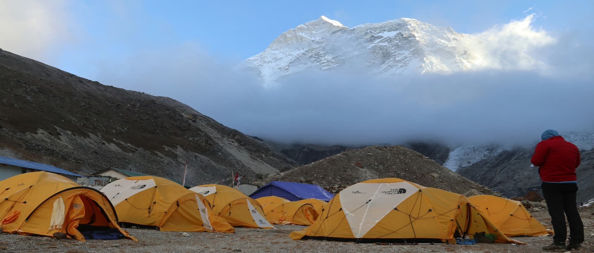
The view from Makalu Base Camp, at approximately 4,870 metres in the Barun Valley, is one of the most concentrated mountain panoramas in the world. Makalu's south face rises almost directly above the camp, its massive pyramid dominating the sky in a way that very few base camps positioned beneath eight-thousanders actually deliver. To the west, Lhotse and Everest are both visible, completing a view that contains three of the world's four highest peaks within a single frame. Baruntse, Chamlang, and a succession of 6,000-metre peaks close the other sides of the valley. An optional day hike to the Swiss Base Camp at around 5,213 metres extends the view further and adds a meaningful physical challenge to a rest day. Even well before the base camp, the high passes of Shipton La at 4,170 metres and Keke La provide panoramic views of the Makalu massif and the surrounding peaks that would constitute the highlight of most other treks in Nepal.
An Uncompromised Cultural Experience
The communities along the Makalu trekking routes have been less reshaped by tourism infrastructure than comparable villages on the Annapurna or Everest routes. This means the cultural exchange a trekker encounters here has a different quality: less mediated, less rehearsed, and more genuinely reciprocal. Being invited to share a meal in a Rai household in the lower valley, watching the morning rituals at a Sherpa gompa in Tashigaon, or sitting with a Bhotia family in the upper pastures while the yaks graze at dusk are not scripted encounters. The people of this region are accustomed to conducting their lives with or without trekking parties passing through, which gives any interaction an authenticity that is valuable and increasingly rare in the more commercially developed mountain corridors.
Best Time and Climate Insights
The Makalu region lies in what is described as the Eastern Himalayan climatic zone, which differs in meaningful ways from the climate of western Nepal. The monsoon arrives earlier, typically in June rather than late June, and persists longer, often through late September, compared to the monsoon's earlier retreat in the Annapurna and Manaslu regions. This slightly extended wet season is the primary reason the region sees fewer trekkers: the viable trekking window is marginally shorter, and the trails in the lower Arun valley can become genuinely slippery and difficult in heavy monsoon conditions.
The autumn season from mid-October through November is the single best period for trekking in the region. After monsoon, the skies over eastern Nepal clear to a depth of blue that is visually distinctive from what western Nepal typically delivers, and the freshly snow-laden peaks of the Makalu massif present their most photogenic faces. Trail conditions are at their most stable, temperatures at lower elevations are comfortably warm during the day, and the high passes, Shipton La and Keke La, are reliably passable for well-equipped teams. Nights at the upper campsites drop below freezing by late October, and early November brings increasingly cold conditions in the Barun Valley, so the window closes progressively through the month.
The spring season from late March through May provides the second viable window. Rhododendrons bloom prolifically through April at the middle elevations, and the forest sections of the lower trek are at their most colourful. The main risk in spring is pre-monsoon precipitation, which begins affecting the region in earnest from mid-May and can bring heavy snowfall to the high passes. Spring weather in the Makalu region is slightly less predictable than autumn, and teams aiming to push to base camp in spring should carry comprehensive camping gear and be prepared for rapid weather changes above 4,000 metres. March and early April are generally more stable than late April and May.
December through February constitutes the winter season, when the high passes become potentially dangerous and the teahouse network in the upper valley partially closes. Lower sections of the route remain walkable for experienced winter trekkers in proper cold-weather gear, but the Makalu Base Camp itself is not a realistic winter objective for most trekking parties. The monsoon months of June through September are not suitable for trekking in this region for most visitors: trail conditions deteriorate significantly, cloud cover obscures the mountain views that constitute the primary visual reward of the upper route, and leeches in the lower forest sections make the approach distinctly unpleasant.
The Main Treks in the Region
Makalu Base Camp Trek
The Makalu Base Camp Trek is the signature route of the region and the one that most trekkers come here specifically to complete. In its standard form, the itinerary runs 17 to 22 days from Kathmandu to Kathmandu, beginning with the flight to Tumlingtar and a jeep ride to Num. The route descends steeply from Num to a suspension bridge over the Arun River and then climbs to Seduwa, where the Makalu Barun National Park checkpoint marks the official entry into the protected area. From Seduwa, the trail continues through dense forest to Tashigaon, the last Sherpa village on the route, before the serious altitude gain begins on the climb to Khongma Danda at approximately 3,500 metres, which serves as the primary acclimatisation stop.
Beyond Khongma Danda, the trail crosses the Shipton La pass at 4,170 metres and the Keke La pass at roughly 4,170 metres as well before descending to Dobate. From Dobate, the route follows the Barun River upstream through the progressively wilder terrain of the upper valley, passing through the high pastures of Yangle Kharka and Langmale Kharka before arriving at Makalu Base Camp at 4,870 metres. The total round-trip covers approximately 120 to 130 kilometres of trail. The difficulty is classified as strenuous: not because of technical terrain, but because of the cumulative physical demand of a long route with significant elevation gain and loss on consecutive days, often on trail that has not been engineered for comfort. This is not a trek for first-timers to high-altitude Nepal without a solid fitness base and prior experience at elevation.
Arun Valley Trek
The Arun Valley Trek is, by most accounts, the more introductory and culturally immersive of the region's two major routes, and one of eastern Nepal's most underrated journeys. The route follows the Arun River through one of the deepest valleys in Nepal, traversing between the Makalu and Everest regions without reaching the altitude of either base camp. The trail passes through Rai, Limbu, and Sherpa villages in rapid succession, crossing the Salpa La pass at 3,349 metres, one of the sacred high passes of the Kirat tradition, marked by a lake and prayer monuments, before connecting into the broader network that links eastern Nepal's trekking circuits.
A standard Arun Valley Trek runs 14 to 18 days and begins with the same flight to Tumlingtar used for the base camp route. The elevation profile is considerably gentler: the highest point at Salpa La is well below the altitude thresholds where altitude sickness becomes a serious concern for acclimatised trekkers, and the lower valley sections remain in subtropical terrain throughout. This makes it a strong option for trekkers who want the cultural richness and biological diversity of the Makalu region without the full commitment of the upper Barun Valley approach. The route also connects naturally with the southern approaches to the Everest region, allowing adventurous trekkers to link the Arun Valley into a longer traverse from eastern Nepal into the Khumbu.
Barun Valley Trek
The Barun Valley Trek is a more focused variant of the full base camp route that prioritises the upper Barun Valley wilderness experience above the cultural and lower-valley sections. It follows the same approach from Num through Tashigaon and Khongma Danda but concentrates more time in the high alpine terrain of the valley above Dobate, with extended days in the meadows and glacial moraines of the upper Barun. For trekkers who have already completed the Makalu Base Camp route and want to return for a more immersive engagement with the upper valley's wildlife, glaciology, and mountain scenery, this focused approach provides the depth of experience that a single-visit itinerary rarely allows. It is also used as the approach route for climbing teams preparing for Baruntse or Mera Peak.
Planning Your Makalu Region Trek
Planning for the Makalu region requires more lead time and logistical care than most popular Nepal treks, primarily because of the limited flight availability to Tumlingtar, the supply constraints in the upper valley, and the need to carry camping and food provisions beyond Tashigaon. The following points cover the essentials for any itinerary in the region.
Permits
The primary permit requirement is the Makalu Barun National Park Conservation Area Permit, currently costing USD 30 per person for the first week and USD 15 for each additional week. A TIMS card (Trekkers' Information Management System) is required at USD 20 per person for independently organised groups. A Makalu Rural Municipality local permit at approximately USD 15 per person is additionally enforced at Tumlingtar. All permits can be obtained in Kathmandu at the Tourist Service Centre in Bhrikutimandap or through a registered trekking agency, and it is strongly advisable to complete all permit processing in Kathmandu before the flight to Tumlingtar. Withdraw sufficient Nepalese rupees in Kathmandu; Tumlingtar has the last reliable ATM on the route.
Getting There
The standard access is a 35 to 45-minute domestic flight from Kathmandu to Tumlingtar followed by a two to three-hour jeep ride to Num. Flight frequency is limited and weather cancellations are more common here than on the Kathmandu–Lukla route. Build at least two buffer days into both the start and end of your itinerary to absorb potential delays. A licensed trekking guide is required for all foreign trekkers under Nepal's 2023 regulation, and practical navigation of the permit system and the logistics from Tumlingtar is significantly easier with an experienced local guide.
Equipment and Supplies
For the Makalu Base Camp route, a four-season sleeping bag rated to minus 20 degrees Celsius, a reliable three-season tent for the upper valley sections, trekking poles, and sturdy boots broken in before arrival are minimum requirements. Camping equipment becomes necessary beyond Tashigaon, and most operators provide this for organised groups. Personal water purification is essential above the teahouse network. Above 4,000 metres, weather can change rapidly, and a comprehensive waterproof shell, insulating layers, and gloves appropriate for near-freezing temperatures are required year-round on the upper route.
Fitness and Experience
The Makalu Base Camp route is not appropriate for first-time Himalayan trekkers without a meaningful fitness base and prior experience of multi-day mountain walking at altitude. A trekking background that includes routes reaching at least 4,000 metres, the physical capacity for six to eight hours of daily walking on rough terrain over two to three consecutive weeks, and genuine comfort with simple trail conditions and limited facilities is the realistic minimum. The Arun Valley Trek is more accessible and can be managed by trekkers with strong general fitness and a high-altitude trekking background even without previous Nepal experience.
Conclusion
The Makalu region is what the more celebrated parts of Nepal used to be before the trails filled. It is not undiscovered, the route to the base camp has been walked by mountaineers and trekkers for decades, and the communities along the way are well accustomed to outside visitors, but it has not been industrialised. The teahouses are small and family-run. The trails are quiet. The wildlife encounters are real. The mountain views, when they come after days of approach through jungle and forest and open pasture, carry the weight of genuine remoteness rather than the expectation of a well-publicised destination.
We bring small, carefully managed groups into this region precisely because the experience it offers is worth protecting. The value of a journey through the Barun Valley or along the Arun River depends in part on the character of the landscape being intact when you arrive, and that character depends on the numbers of people moving through it remaining at a level the ecosystem and the communities can absorb without pressure. If that kind of travel resonates with what you are looking for in Nepal, the Makalu region is worth serious consideration. Reach out to our team to discuss the season, the right route for your fitness and experience level, and what a well-planned Makalu expedition would look like for you.
Frequently Asked Questions
1. What is the Makalu region in Nepal?
The Makalu region is a remote trekking area in northeastern Nepal, centred on Makalu Barun National Park and the valleys of the Arun and Barun rivers. It is named after Mount Makalu at 8,463 metres, the world's fifth-highest peak. The region sits between the Everest area to the west and Kanchenjunga to the east in Sankhuwasabha and Solukhumbu districts, and is protected within a national park that holds the unique distinction of encompassing more than 8,000 metres of elevation gain within a single boundary, from tropical floodplain to glaciated summit.
2. Is the Makalu Base Camp Trek harder than the Everest Base Camp Trek?
In physical terms, yes, the Makalu Base Camp Trek is generally considered more demanding than the standard Everest Base Camp route. The trail is rougher and less engineered, the daily elevation gains are more variable and sometimes steep, the total distance is comparable, and the infrastructure above Tashigaon requires carrying camping provisions rather than relying on teahouses throughout. The altitude at Makalu Base Camp (4,870 metres) is also higher than Everest Base Camp (5,364 metres) is often cited, though both figures are approximate depending on the specific camp location used. The Everest Base Camp Trek benefits from decades of trail maintenance and a comprehensive teahouse network that the Makalu route does not yet replicate in its upper sections.
3. How many days does the Makalu Base Camp Trek take?
A standard Makalu Base Camp Trek itinerary runs 17 to 22 days from Kathmandu to Kathmandu. The range reflects different pace preferences and the inclusion of acclimatisation days: most experienced operators use at least one rest day at Khongma Danda (roughly 3,500 m) and an exploration day at the base camp itself. Shorter 15-day itineraries exist but compress the acclimatisation schedule in a way that meaningfully increases altitude risk and are not something we recommend for most trekkers. Adding two to three buffer days around the domestic flights to and from Tumlingtar is strongly advisable given the frequency of weather-related delays on that route.
4. What permits are required for trekking in the Makalu region?
Three permits are currently required for the Makalu Base Camp route. The Makalu Barun National Park Conservation Area Permit costs USD 30 per person for the first week and USD 15 for each additional week. The TIMS card (Trekkers' Information Management System) costs USD 20 per person. A Makalu Rural Municipality local permit at approximately USD 15 per person is required at the entry point. All of these can be obtained through a registered trekking company or at the Tourist Service Centre in Kathmandu. We handle permit processing for all trekkers who book through us, and it is considerably easier to complete this in Kathmandu than to attempt it at Tumlingtar.
5. What wildlife can I expect to see in the Makalu Barun National Park?
The park supports one of the most diverse wildlife assemblages of any protected area in the Himalayas. Documented species include snow leopard, clouded leopard, red panda, Himalayan black bear, Himalayan tahr, musk deer, serow, ghoral, barking deer, langur monkey, and Himalayan marmot, among over 100 mammal species. Over 400 bird species have been recorded, making the park a significant destination for ornithologists, and the Arun River supports 84 fish species. In practice, the wildlife encounters most trekkers describe are bird sightings in the forest sections and red panda sightings in the rhododendron and bamboo zones around 2,500 to 3,500 metres. Snow leopard sightings are possible but rare. The biological diversity is most vivid in the lower and middle elevation zones, particularly in spring when the forest is actively populated with migratory birds.
6. How do I get to the trailhead for the Makalu region?
The standard access from Kathmandu is a 35 to 45-minute domestic flight to Tumlingtar airport followed by a jeep drive of roughly two to three hours to Num village, the primary trailhead for the Makalu Base Camp route. Flight costs are approximately USD 120 to USD 150 one way as of 2025. Flights to Tumlingtar are less frequent than on the Everest corridor and are more susceptible to weather delays. An overland alternative by bus from Kathmandu is possible but takes two to three days each way on difficult roads and is not practical for most trekkers. We book flexible domestic flights for all our Makalu groups and build buffer days into both ends of the itinerary to account for potential cancellations.
7. What is the best time of year to trek in the Makalu region?
The autumn season from mid-October to late November is the preferred window for most trekkers: post-monsoon skies are clear, the mountain views are at their most dramatic, and trail conditions are stable. October is the busiest month within this window, though 'busy' in the Makalu context means very few other parties rather than the crowds familiar from Everest or Annapurna. The spring season from late March through early May is the second option, with rhododendron blooms through April and generally good visibility, though pre-monsoon precipitation can affect conditions from mid-May onward. The monsoon months of June through September are not suitable for the full route. Winter trekking in the lower valley is possible for well-equipped and experienced parties, but the high passes become unreliable and the base camp is not a realistic winter objective.
8. Is the Makalu region suitable for first-time trekkers in Nepal?
The Makalu Base Camp route is not the ideal first trekking experience in Nepal, due to its length, infrastructure limitations above Tashigaon, and the sustained physical demands of the approach. The Arun Valley Trek within the same region is considerably more appropriate for trekkers newer to Himalayan environments: it stays at more manageable altitudes, the teahouse network is more consistent throughout, and the cultural richness of the lower valley provides an engaging experience without the logistical complexity of the upper route. For trekkers committed to reaching the base camp on a first Nepal trek, an excellent fitness base, prior experience at moderate altitude, and a well-supported guided itinerary with conservative acclimatisation days are the minimum requirements.
9. How does the Makalu region compare to the Everest region for trekking?
The two regions share an administrative boundary and visible peaks, but the experience they offer is substantially different. The Everest region has the most developed trekking infrastructure in Nepal: a dense teahouse network, regular helicopter evacuation services, reliable Wi-Fi in most major stops, and a well-maintained trail that sees tens of thousands of visitors annually. The Makalu region has a fraction of this infrastructure, particularly above Tashigaon, and sees a small fraction of the annual visitor numbers. What it offers in return is genuinely uncrowded trail, a richer wildlife environment, more authentic community interactions, and the specific visual experience of the Barun Valley and Makalu's south face that have no equivalent in the Khumbu corridor. For trekkers who have already done the Everest routes and want something more demanding and less formulaic, the Makalu region is the most logical next step in eastern Nepal.
10. Can I combine the Makalu Base Camp Trek with a visit to Everest Base Camp?
A traverse connecting the Makalu and Everest regions is possible and has been done by experienced trekking parties, typically via high passes that cross the western boundary of Makalu Barun National Park into the Khumbu. This is a serious multi-week undertaking that involves remote terrain, significant altitude, and sections requiring camping capability well beyond the standard teahouse network. It is not a route for casual trekkers and requires a strong mountaineering background, a fully equipped team, and considerable logistical planning. The Arun Valley route, which travels between the Makalu and Everest regions at lower altitude, is a more realistic combination for experienced trekkers who want to link the two regions in a single journey without crossing the high technical terrain of the upper passes.