No cancellation fees. No hassle. Book Now, Cancellation Terms
More about Mera Peak Climbing
10 min readMera Peak Expedition Itinerary: Complete Day-by-Day Climbing Guide
March 16, 2026
10 min
463 views
Mera Peak (6,476m/21,247ft) is the highest trekking peak in Nepal, perched in the Everest (Sagarmatha) region. It offers an unforgettable Himalayan experience – trekking through remote Sherpa villages and rhododendron forests, then climbing a non-technical glacier route to stand among the world’s tallest mountains (Everest, Lhotse, Kanchenjunga, Makalu, Cho Oyu). In spring (March-May), the weather is most favorable – clear skies, stable conditions, and blossoming rhododendrons make this the “peak climbing season". (Autumn (Sept–Nov) is the second-best season; monsoon and winter are generally avoided.) This step-by-step itinerary (about 18–21 days including travel days) shows a typical spring ascent of Mera Peak, as arranged by Kathmandu-based operators like Accessible Adventure, ensuring you have expert support on every day of the trek.
Planning and Preparation
Before the trek, you’ll need a Nepal tourist visa and permits. US citizens can obtain a visa on arrival at Kathmandu airport (e.g. ~US$50 for 30 days). Climbing Mera Peak also requires a permit from the Nepal Mountaineering Association (approximately US$250 in spring) plus entry permits for Makalu-Barun National Park (~US$30) and the local Khumbu Pasang Lhamu Rural Municipality (~US$20). Trekking agencies handle these logistics for you, but be sure to carry copies of all paperwork.
Physical preparation is essential: Mera Peak is non-technical, but its altitude makes it strenuous. Guides recommend having prior high-altitude trekking experience (for example, being comfortable above 5,500m) and doing 4–6 weeks of cardiovascular training before departure. Good hiking boots, warm clothes, and technical gear (crampons, ice axe, helmet) are needed. If you don’t own gear, Kathmandu’s Thamel district has shops where you can rent or buy what you need. Travel insurance covering high-altitude evacuation is a must – standard policies usually don’t include helicopter rescue.
Finally, allow time to acclimatize. The itinerary below builds in gradual altitude gains and rest days. Follow these acclimatization tips: climb high but sleep lower, take frequent breaks, stay hydrated, and listen to your body. Watch for symptoms (headache, dizziness, nausea); do not push higher if you feel ill.
Acclimatization Tips:
-
“Climb high, sleep low.” Whenever possible, gain altitude during the day but descend to sleep at a lower elevation.
-
Keep a steady pace. Take it slow on steep sections.
-
Hydrate, hydrate, hydrate. Drink plenty of water and avoid alcohol.
-
Know the warning signs. Headache, shortness of breath, or extreme fatigue are red flags. Pause or descend if needed.
Day 1: Arrive in Kathmandu (1,400m)
Your adventure begins the moment you land at Kathmandu’s Tribhuvan International Airport. After visa formalities (expect about US$50 for a 30-day tourist visa), your guide or agency representative will meet you at the arrivals hall. A private transfer will take you to a hotel in Kathmandu (sitting at ~1,400m altitude), where you can rest. This first day is for recovery from jet lag; Kathmandu’s mild altitude means there’s no serious risk of altitude sickness yet. You might walk around the hotel’s neighborhood (Thamel) or relax, but most climbers simply check into the hotel and enjoy a good dinner.
Pro Tip: Nepal’s time zone is UTC+5:45. It’s 10–12 hours ahead of the U.S. depending on your coast. Keep an eye on your watch when flying – Kathmandu’s unique offset can be easy to overlook!
Day 2: Kathmandu – Gear Check and Sightseeing
Spend this day finalizing preparations. In the morning, meet with your expedition leader and crew to review the route and logistics. They will check your trekking equipment, suggest any missing items (for instance, renting crampons or an ice axe if you lack them), and make sure all paperwork (permits, TIMS card, etc.) is in order. Often, a pre-trek briefing includes a short classroom session or presentation at the company office, as shown above, to go over safety, packing tips, and the schedule.
Use the afternoon for a touch of sightseeing and final shopping. Kathmandu is rich in culture: many itineraries offer a half-day tour to Boudhanath Stupa, Swayambhunath (“Monkey Temple”), or Pashupatinath temple. (Even a quick stroll in Thamel is fun; you can buy trekking snacks, SIM cards, and warm gear just in case.) Enjoy an early night: tomorrow is an early start.
Day 3: Fly to Lukla (2,840m) and Trek to Paiya (2,735m, 4–6 hrs)
Your Himalayan trek truly starts with the legendary flight to Lukla. Early this morning, you’ll drive to the domestic terminal for the ~40-minute flight into the Khumbu region. The small STOL plane to Lukla hugs the mountainside, offering breathtaking panoramas of Everest, Lhotse, Cho Oyu, and the surrounding range. It’s one of the world’s most scenic (and adventurous) short flights. During peak trekking seasons, flights may operate from Ramechhap/Manthali airport instead – in that case, you’d take a 3–5 am drive east and fly from there to Lukla.
After landing at Lukla (2,840m), you’ll meet your climbing porters and begin walking. The trail initially winds above Lukla through pine forests. Within a few hours, you’ll reach Paiya (also spelled Puiya, about 2,735m) for the first night’s camp. The route crosses the Handi Khola (river) and ascends a small pass called Chutok La (2,800m) along the way. Paiya is a small Sherpa village where the surrounding hills offer good sunset views. Today’s hike of ~5 hours lets you take in greenery and mountains without a huge altitude jump, helping you acclimatize gradually.
Day 4: Trek to Panggom (2,846m, 5–6 hrs)
From Paiya, the trail first dips and then climbs steeply through mountain jungle. You ascend to Kari La (about 2,990m), a pass where you get your first glimpse of Cho Oyu’s great pyramid peak off to the north. The surroundings turn alpine as you gain elevation. After crossing the pass, the route descends into the broader Hinku Valley. The hike continues through rhododendron and bamboo forests, with high peaks coming into view on the horizon.
By late afternoon, you’ll reach Panggom Village (2,846m), another remote Sherpa settlement. This overnight stop has simple lodges and a small gompa (Buddhist monastery). Climbing guides note that this part of the trek is “an off-beat venture in the less crowded Khumbu region”, meaning you’ll often walk alone or in small groups amid traditional villages. From Panggom, you may even see peaks like Makalu or Baruntse.
Day 5: Trek to Ningsow (2,863m) via Ramailo Danda (3,276m, 4–5 hrs)
You continue trekking up the Hinku valley. The trail soon climbs to Panggom La (~3,180m), offering more wide-open views. After the pass, you descend across alpine meadows and yak pastures. Along the way, you’ll cross streams like the Kharka Khola, and may stop in a small cluster of huts at Ningsow (Ningsow) Village (2,863m) for lunch.
If everyone is feeling strong, the team often pushes on toward Ramailo Danda (“pleasant hill,” 3,276m). This ridge-top camp is strategically located for acclimatization. From there, you will be standing above the broader Hinku valley with sweeping panoramas – including the snow-capped summit of Mera Peak rising ahead. Tonight’s camp is on the ridge, giving you a full view of Mera (to the south) and the distinctive Salpa (Vermilion) mountain. The altitude of Ramailo Danda is high enough to help your body adapt, so you’ll have gained almost 1,000m in two days of hiking.
Day 6: Trek to Chhatra Khola (Bamboo Camp, 2,800m, 7–8 hrs)
On Day 6, you descend back to the Hinku River and then continue up-valley. The trail drops from Ramailo Danda into a gorge, crossing through bamboo forests (“Chhatra” means bamboo). Here you actually enter Makalu-Barun National Park, the protected area that covers this part of the valley. The environment is richly forested and less traveled, so keep an eye out for wildlife – even red pandas have been spotted here.
By afternoon, you reach Chhatra Khola (Bamboo Camp) (2,800m), named for the dense bamboo thickets along the stream. It’s a simple camp with a few tea houses. From here, you should already be feeling more acclimatized, and the contrast from yesterday (very high) to today (much lower) is deliberate. Enjoy the river valley, and get rest – tomorrow you begin the long climb into the high alpine.
Day 7: Trek to Kothe (3,691m, 6–7 hrs)
The trail today leads you further up the valley. Crossing a few small ridges, you come to a junction called Trashingo. From here, the path swings east to follow the main Hinku Khola. After fording the Majang Khola stream and then the Hinku Khola itself, you arrive at Kothe (3,691m) by late afternoon. Kothe is a larger village with more lodges, and it marks the end of the forested section. Above Kothe, the trees start to thin, and you’ll spend the night gazing at high peaks across the valley. From here, you have climbed nearly 900m above Bamboo Camp.
Day 8: Trek to Thangnak (4,356m, 5–6 hrs)
From Kothe, the trail becomes steadily steeper and rockier. You follow the Hinku Glacier’s lateral moraine, ascending through alpine shrubs. After a few hours, you emerge at Thangnak (also spelled Tagnak) at 4,356m. This is a full day’s trek, but only about 5–6 hours. En route, you’ll see amazing views: the north face of Mera looms ahead, and to the west, the distinctive pyramid of Kusum Kanguru is visible. Thangnak is a small settlement of tea houses and a mani wall, set on moraine rubble below Mera. You’ll spend two nights here to rest and acclimatize.
Acclimatization Day (Thangnak): Take a rest day at Thangnak. You’ll notice your sleeping altitude (4356m) is higher than any previous night, so let your body adjust. In the afternoon, you can do a short hike up to the Tibetan Prayer Stones (a hill directly above camp) to help acclimatize. This 2–3 hour side-trip gains about 200–300m elevation and offers panoramic views of the route; returning to the same camp keeps your sleeping altitude low. (Guides often recommend this “climb up and back” approach: it raises your circulation without having to sleep higher.) Rest well tonight, drink plenty of fluids, and eat a good meal.
Day 9: Trek to Khare (5,045m, 3–4 hrs)
Now you leave the comfortable tea houses and enter true high-altitude terrain. The trail from Thangnak crosses the Dig Glacier moraine and gradually climbs through loose rock and scree. In about 3–4 hours, you reach Khare (pronounced KHAH-re, 5,045m). This is the last outpost village, located at the edge of the Mera Glacier. Above Khare lies the Pang Pema ridge and Mera Base Camp beyond it. In Khare, you’ll find a few teahouses with basic accommodations (shared dorms, simple meals).
Khare is your final acclimatization camp. Spend the day resting and preparing for the climb. The afternoon is used for practicing gear: guides will fit crampons and have you try on harnesses and helmets. You can also hike around nearby ridges (for example, a short climb up to Nepal Peak or a glacial viewpoint) to aid acclimation. Dinner is early, and you’ll get to bed by 7–8pm to be ready for the summit push.
Summit Stage: Khare → Mera Base Camp/High Camp (5,780m) → Summit (6,476m) → Back to Khare
Day 10: High Camp (5,780m). Early (around 6–7 am), begin the steep climb from Khare up to Mera Base Camp (5,350m) and on to High Camp at 5,780m. This is a 4–5 hour ascent. The route is rocky and glacial: you will often use fixed ropes and steps cut in the ice. By afternoon, you reach High Camp, a campsite near a mound called Pang La. High Camp offers stunning 360° panoramas: from here you can see Everest (south face), Lhotse, Cho-Oyu, Makalu, Kangchenjunga, and the many peaks of the Everest region. Tonight, you stay in a tent or basic hut to rest for summit day.
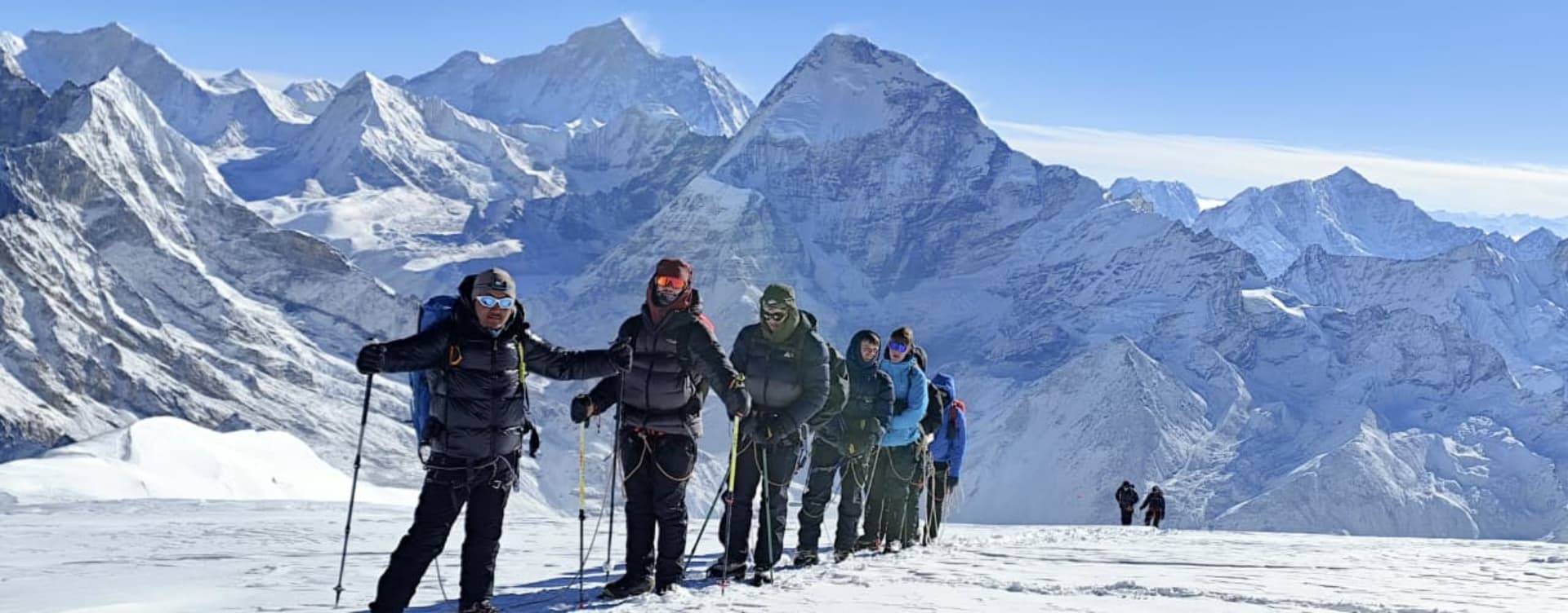
Day 11 (Summit Day, ~12–15 hrs total). Wake in the pre-dawn darkness (around 2–3 am) for the summit push. You put on down gear and head up the snowy East flank of Mera Peak with headlamps. The steep snow/ice slopes are climbed in near-silence and cold as you gradually gain elevation. The guide will use crampons and fixed lines on the steepest sections. By around 7–8 am, you reach the summit (6,476m).
At the top, the sun rises over the Himalayas, and you are standing on Nepal’s highest trekking peak! The view is extraordinary: five 8,000m peaks (Everest, Lhotse, Makalu, Cho Oyu, Kanchenjunga) are all visible along the horizon. Take photos and enjoy the 360-degree panorama. It usually stays peaceful on Mera’s summit (unlike Everest, where there may be crowds). After about 15–30 minutes, you retrace your steps. Descend carefully, reaching Khare again by late afternoon. The total round-trip can be 12–15 hours, depending on conditions. Tonight’s camp is back in Khare. (Summit day is long and tough – make sure to rest well here.)
Climbers on Mera Peak’s summit (6,476m). From here, you see Everest (far right) and four other 8,000m peaks
Day 12: Reserve/Recovery Day. This day is held in reserve in case bad weather delays the summit. If you summited as planned, you can simply relax in Khare, mend equipment, and enjoy the high alpine scenery. If the weather on Day 11 was poor, use this day to try the summit again. In practice, many groups rest here to recover from the summit climb. (If all goes smoothly, this extra day just adds breathing room. If needed, it can be skipped or spent hiking locally.)
Descent: Khare → Lukla and Return to Kathmandu
Day 13: Trek from Khare to Kothe (3,691m, 4–5 hrs). Begin descending from Khare to lower altitudes. Retrace your ascent route: hike down through Thangnak and return to Kothe. This downhill day is much easier on the body and lets you enjoy views of the green valley again. Overnight at Kothe.
Day 14: Trek from Kothe to Thuli Kharka (4,300m, 5–6 hrs). Although you’re descending overall, there is still a high ridge to cross. Head up and over a hill at Taktor, then traverse across steep slopes through marshy yak pastures. You’ll pass old mani walls and chortens (Buddhist shrines) along the way. Eventually, you reach Thuli Kharka (4,300m), a broad high pasture. Overnight at the teahouse here.
Day 15: Thuli Kharka → Zatrwa La (4,600m) → Lukla (2,840m, 6–7 hrs). This is the final long day. From Thuli Kharka, you climb to the Zatrwa La pass (4,600m), which offers one last expansive view back down the valley. After topping the pass, it’s a long descent into the Dudh Koshi drainage. By afternoon, you will re-enter forested lower altitudes. Finally, you reach Lukla again (2,840m) for the night. Lukla is lively with trekkers returning from various peaks.
Day 16: Fly back to Kathmandu (1,400m). An early morning flight brings you from Lukla back to Kathmandu’s airport (about 35–40 minutes). In spring, this is usually a direct flight; in some busy periods, flights go via Ramechhap (Manthali), requiring an extra road transfer of ~5–6 hours. Back in Kathmandu, you check into a hotel. This afternoon is free – many trekkers enjoy a hot shower, visit the markets of Thamel, or get a relaxing massage. This is a good time to tour any Kathmandu sites you missed on Day 2, or simply rest.
Note: Because weather in the Himalaya can be unpredictable, some itineraries build in an extra Kathmandu day here. If you have that time, you can do more sightseeing (e.g. Pashupatinath, Boudhanath, or Swayambhunath temples as recommended by Annapurna Foothills). Otherwise, enjoy the hotel and celebrate – you’ve earned it!
Day 17: Depart Kathmandu or Extra Free Day
After breakfast, your trip ends. A private transfer will take you to Tribhuvan Airport for your international flight home. (Plan to arrive at least 2–3 hours before your flight time.) You leave Nepal with memories of wild valleys, towering peaks, and an unforgettable summit. Many travelers conclude with a farewell dinner in Kathmandu (often included by operators), toasting the success of the expedition.
Summary: This detailed itinerary (roughly 16–18 days from Kathmandu back to Kathmandu) is designed for spring conditions. It carefully alternates trekking days with necessary rest for acclimatization. In total, you’ll hike through Everest‑region Sherpa villages (Paiya, Panggom, Ningsow, Kothe), spend nights under alpine skies (Thangnak, Khare), and make a gradual summit push. The return route via the Zatrwa La Pass offers new vistas on descent. Agencies like Accessible Adventure have perfected these day-by-day schedules to maximize safety and enjoyment. By following this plan and listening to your guides, US travelers can confidently take on Mera Peak and come home with the reward of having stood on Nepal’s highest trekking summit.
About Accessible Adventure
Bringing unforgettable Himalayan adventures to everyone. Our expert guides and carefully curated experiences ensure that everyone can explore the beauty of Nepal, Tibet, and Bhutan.
Learn More