During the Jomolhari Yaksa Trek, travelers will see some of the world's most biologically diverse habitats while taking in breathtaking panoramas of Mt. Jomolhari (7314 meters), as well as its neighbors Jichu Drake (6794 meters) and Tshering Gang. This hike will take you to the foot of Mt. Jomolhari, which is the second highest peak in the world that has not been climbed. It is one of the best treks for nature enthusiasts since it combines seeing secluded communities in the region that borders Tibet with stunning vistas of the surrounding mountains and alpine pastures. Once the road comes to an end, the hike begins with a passage through alpine meadows with the beautiful Jomolhari peak looming at the valley head. The hike begins in Paro with a drive towards the Drukgyal Dzong. During the hike, you will have the opportunity to fish for trout at Lake Tshophu, which is located at a high height. In addition, the show travels to all of the significant cities in Bhutan, such as the colorful Paro, the diminutive capital city of Thimphu, and Punakha, the country's former capital city. During the sightseeing, a number of historical and religious landmarks are visited, such as the Punakha Dzong and the Chimi Lhakhang. The most intriguing walk is to the Taktsang Monastery, also known as the "Tiger's Nest," which is set in a vertical cliff.
The breathtaking panorama of Mount Jomolhari that can be enjoyed from Jomolhari Basecamp in Jangothang is the highlight of this hike. The majority of the journey is spent traveling through a section of Jigme Singye National Park. Along the way, travelers will come across a few Yak herder communities and the most isolated part of Lingshi.
Bhutan is not only endowed with a wealth of cultural beauty, but it is also exceptionally blessed in terms of the natural beauty of its landscape. The natural splendor of Bhutan cannot be rivaled by any other place. Both the administration of the country and the people who were born and raised there have worked very hard to make this come to fruition. According to the National Forest Policy that was created in 1974, the government has the responsibility of maintaining a forest cover that is at least 60% of the total land area. The nation's objective has not only been met, but it has been blown away by a twenty percent margin. The Bhutan Land Cover Assessment that was carried out in 2010 found that the country of Bhutan is covered with more than 80 percent forest, and this percentage has been steadily increasing year after year since the study was first carried out. During the Jomolhari Yaksa journey, we will be walking through a number of different forest trails, and the best example of this truth may be observed in those trails.
The spring months of March to May are the ideal time to travel to Bhutan because this is when the country's valleys are at their most beautiful and vibrant. Whether it be in its festivals or celebrations, clear sky and vistas to the Himalayan peaks, abundant Himalayan flora and wildlife, or just gorgeous snowfall, the Himalayas have much to offer. You are guaranteed to have a wonderful time in Bhutan amidst nature and all of its stunning offspring and to bring back with you a memory that you will treasure for the rest of your life. The months of June through August are considered the shoulder season because of the rain, which makes hiking and other outdoor activities less appealing.
During the autumn season, however, it is the festive season, and getting a travel permit as well as proper hotel rooms might be difficult. The trails will also be slightly crowded with tourists so even though it is one of the best seasons, these cons have to be taken into consideration.
The summer season is the tourist low season with a relatively lower influx of tourists.
The climates of Bhutan's northern, central, and southern regions couldn't be more different from one another. The climate of the northern region of Bhutan is characterized by year-round freezing temperatures, snow-covered peaks, and mountains, while the climate of the central region alternates between hot summers and mild winters. The climate of the southern region of Bhutan is characterized by a subtropical climate that is characterized by hot and humid climatic conditions that are constant throughout the year.
Accessible Adventure is a travel and tour company that is managed and operated by a group of Nepalese people who have years of expertise in the industry. The team in question has extensive expertise in planning and managing holiday destinations in Bhutan, Nepal, and Tibet, all of which are located in the Himalayas.
We are a leading and rising travel company based in Kathmandu, Nepal, with over a decade of experience in successfully executing trips by providing one-of-a-kind quality services at reasonable prices. Our organization is located in Nepal. During the time that you are here with us, you will have access to all of the wonderful holiday spots in the Himalayas that we can provide.
Every one of our trips is painstakingly planned and arranged, and we consistently receive great comments from both previous customers and clients as well as those who are still using our services. They have expressed a high level of happiness and gratitude for the value that we bring to their trips.
You have arrived in Bhutan, also known as the Land of the Thunder Dragon. When you arrive at Paro International Airport, your guide will be waiting for you just outside the arrivals hall to give you a warm welcome. We will take it easy today so that our bodies can adjust to the higher altitude. Travel to Thimphu, check into your accommodation, and then we'll take you out for your first taste of Bhutanese food. If time permits, we'll also do some light sightseeing around Thimphu.
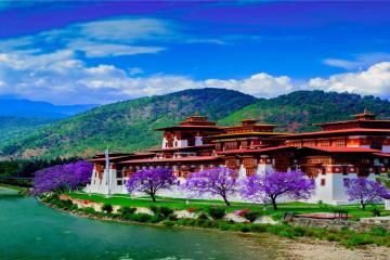
This picture-perfect part of the kingdom, Paro, is characterized by its abundance of rich rice fields and a stunning river with crystalline waters that flows through the valley. The town of Paro is home to a greater number of historical landmarks, upscale tourist resorts, and numerous souvenir shops, one of which is the internationally renowned Takstang Monastaru. The Taktsang Monastery, also known as the Tiger Nest Temple, is often regarded as the most recognizable symbol of Bhutan and an important Buddhist pilgrimage site worldwide. The meaning of the word Taktsang in Tibetan is "The Nest of the Tiger." The temple, which is considered to be one of the holiest sites in Bhutan, is perched precariously on a cliff face that is 900 meters above the valley floor. The majority of hikers take the entire day to traverse the trail, despite the fact that experienced trekkers can reach the summit in just two hours. The Buddhist King Songstsen Gampo of Tibet erected the Kyichu Lhakhang Temple, also known as the sacred Jewel of Bhutan, in order to vanquish the enormous ogress that lay across Tibet and the Himalayas, blocking the spread of Buddhism. It is thought that the king constructed the temple that may be found near the left foot of the gigantic ogress. You can go for a hotspring bath nearby as well with additional cost.
Today we take the Chele La route to Haa (3,988 m). From the top of the pass, you will have a view of Haa valley to one side and Paro valley to the other. . After doing some sight-seeing in Haa, we traveled to the nearby community of Katsho and went to the Katso Lhakhang. Haa is Bhutan's least frequented valley because there isn't much in the way of tourist infrastructure there. The valley of Haa didn't even start welcoming visitors until 2002. However, the views and sights from Haa, seen untouched in many cases by human urbanization are a welcome sight. When you are in Haa, you can explore the traditional Bhutanese way of life. Because Haa valley does not have any hotels suitable for tourists, we have to head back to Paro for the night.
Today, after we have breakfast and get ready, we will pay a short visit to the Drukgyel Dzong. The Zhabdrung ordered the construction of the Drukgyel Dzong in 1654 as a monument to commemorate one of the numerous victories won in battle over the Tibetans. It stood to watch over the path that led from Tibet into the Paro valley for hundreds of years. We are going to travel to Shana by car. Immediately before arriving at the location where we will begin our hike, we will have to go through an army check post. At the check post, your guide will get your hiking permission for you. The path from Shana to Thangthangkha is extremely rocky and consists of a series of little ups and downs along the Paro Chu. If it has rained recently, the track may also be very muddy. After around two and a half hours of hiking, you will arrive at a crossroads from which an old path leads in the direction of Tibet. Have a good time spending the night at the camp.
Today, the trail goes uphill for a long time until it finally arrives at the military camp. After a short time spent in the military camp and registering there, we climb above the tree line and continue to follow the river while taking in the breathtaking vistas of the mountains all around us.
After making your way through the larch forest that covers the mountainside, the trail will eventually lead you to the settlement of Soe. The image then abruptly shifts, and you find yourself looking at residents herding yaks instead of the previous landscape. If you are concerned that you have not encountered any highland hamlets along the journey, then a collection of stone dwellings situated on a plateau at 3,940 meters will soon come into view after you have traveled for one hour in the direction of Takethang.
The village of Dangochang is one of the several that you will have to travel through on your way to Janothang Base Camp in the end. The villagers here make their living by tending to yaks and sheep as well as cultivating various root vegetables and tubers such as potato, turnip, and radish.
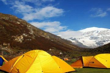
At the camp of yak herders, you will be served lunch. After lunch, we reach our camping spot at Jangothang with just a little stroll down into the valley from where we had lunch (4,040m). The views of Jhomolhari and Jichu Drake are breathtaking from this vantage point. We set up camp amid the mountains and prepare for the walk tomorrow.
This is one of the longest days of the trek. A short distance from the camp the trail begins climbing rapidly for about half an hour and then becomes a gradual ascent to the Nyilila pass at 4,870m. While on the climb enjoy the surroundings. You might see herds of blue sheep grazing on the slopes of the mountains. From the pass you will have spectacular views of Mt. Jomolhari, Jichu Drake and Tsherimgang, all of them rising above 7,000m. The path eventually reaches the bridge that leads to the right bank. The ascent up to the first ridge begins right now, and along the way, we will take in the beautiful vistas of Chomolhari, Jichu Drake, and Tserimgang. The path then leads us over the floor of the valley, which is very flat, until we begin the ascent to Nyele-la pass (4,700m). As we make our way down from the pass to our campsite at Lingshi (4,000ml), we take in the breathtaking vistas of the surrounding mountain peaks and the Lingshi Dzong.
You need to get an early start on today's hike because you have a long and strenuous walk ahead of you on the itinerary. Keep your attention focused on several blue sheep who are grazing nearby. The first half of the hike takes place primarily along a treeless valley until we begin the ascent to the Yale-la pass, which is located at 4950 meters. When the weather is clear, we are able to see Mount Jumolhari, Mount Tsherimgang, and Mount Masagang. Because the Yale la is used by nomads on their journey between Lingshi and Thimphu, the path is quite clearly marked. After descending the pass, travelers will find themselves at the confluence of the Jaradinthang Chhu and the Thimphu Chhu. A chorten, also known as a stupa, can be found at an elevation of 4,150 meters; from there, the path continues in an easterly direction while following the river. Just after traversing the sandy hill, you will come to Shodu, where the camp is located.
Following the Thimphu Chhu through the limestone valley, today's hike includes a number of steep ascents and descents. Caves are a popular place for monks to meditate. When Shabdrung fled Tibet in the 17th century, legend has it that he meditated in these rocks on his way out of the country. We will have a wonderful opportunity to take in the scenery of the imposing rock walls and waterfalls. The hike to Barshong Dzongs, which are now in ruins, involves a gradual ascent of around 130 meters. The community of Barshong is quite small, consisting of only around a half dozen homes and their occupants.
The last day of proper trekking begins with a descent that is more gentle than usual through woodland that is filled with magnificent rhododendron bushes. If you continue down the trail, you will soon arrive at Ta Gume Thang, also known as Waiting for Horses, which is a clearing at 3,370 meters where you can set up camp. There are multiple ascents and descents and crossings of a few smaller streams. You will come to a fork in the route; taking the one that bears right will lead you to the campground you will use for the night.
This day's hike is a leisurely stroll with only a few moderate inclines and declines, followed by a handful of hard switchbacks down down a vertical cliff, and then eventually arriving at the final section of the trail leading to Dodina. After descending through bamboo forests and following a mule trail high above the river, the path finally brings you to Dodina, where your car will be waiting to pick you up and drive you the remaining thirty minutes to Thimphu, the contemporary capital of Bhutan. Around 98,500 people call Thimphu home at any given time. The city consists of little more than three parallel rows of retail establishments and is the only capital in the world that does not have traffic signals.
This morning, we will have breakfast together one last time in this breathtaking Himalayan nation before boarding our journey back. We have high hopes that by now you have not only accumulated many images but also some wonderful recollections of your time spent in Bhutan. And we look forward to welcoming you back to this wonderful world of never-ending enchantments when you do so! Tashi Delek!
Want to make your own customized trip ? Click Here